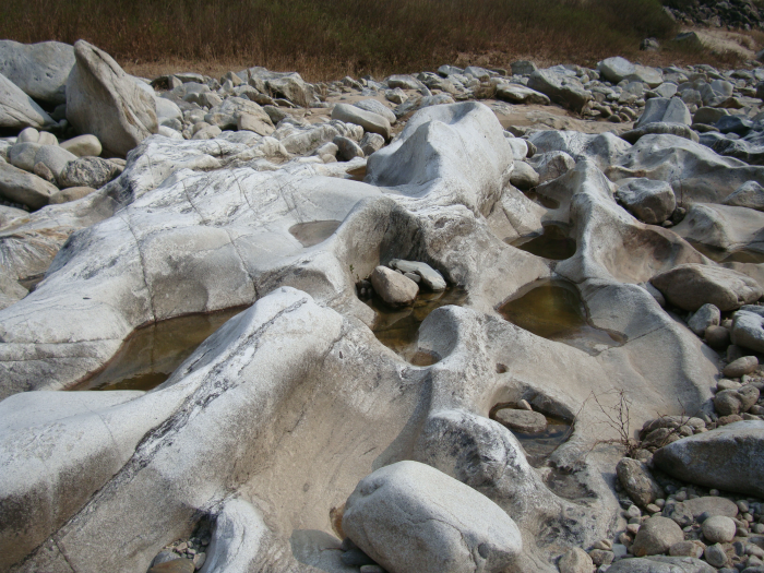
Naerincheon River Pothole-Gangwon Peace National Geopark (내린천 포트홀-강원평화지역 국가지질공원)
11.8 Km 18291 2019-09-04
Buk-ri, Girin-myeon, Inje-gun, Gangwon-do
+82-33-249-3881
Naerincheon River starts out as a small stream on Bungnyongsan Mountain and flows down Sogyebangsan Mountain before joining with other small valley streams to create the larger river that most people know. The river has created a valley with many interesting and uniquely shaped rocks as it flowed down the mountainside over the years. The waters are so pure, the small pebbles and sand lining the bottom of the stream can be seen clearly. There are a number of areas along the stream perfect for relaxing and enjoying some time in nature. Many families visit and enjoy fishing and the pure environment. The river is also well-known for rafting.
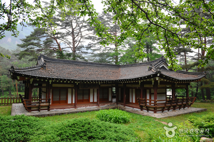
Jangsudae Pavilion (장수대)
14.7 Km 8983 2020-03-24
4193, Seorak-ro, Inje-gun, Gangwon-do
+82-33-463-3476
Jangsudae Pavilion was completed on October 1, 1959 to commemorate the great victory of the battle held at Seoraksan Mountain during the Korean War. It serves as a resting spot for visitors who hike up the park to visit attractions nearby such as the Daeseung Falls, Oknyeotang Spring, Gamatang Spring, Hangyesanseong Fortress, and Haneulbyeok Wall. The pavilion is built in a traditional Korean style and considered as an excellent hermitage in terms of both structure and size. The surrounding nature consisting of mountain cliffs and pine forest makes the building stand out even more.
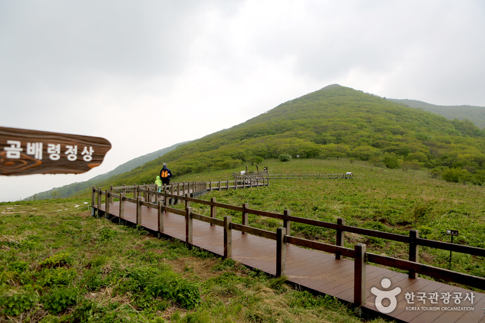
Jeombongsan Mountain Gombaeryeong Pass (점봉산 곰배령)
15.0 Km 89981 2024-02-16
12 Gombaeryeong-gil, Girin-myeon, Inje-gun, Gangwon-do
This ecological area at the summit of Jeombongsan Mountain, situated 1,100 meters above sea level, spans approximately 16.5 hectares. It is often referred to as the "garden of heaven" due to the sheer diversity of plants and wildflowers in the area. The trail leading to the pass has a relatively gentle slope, making it accessible to all. It extends for 10.5 kilometers and typically takes about four hours to complete. Visitors need to make reservations to visit the pass.

Yongneup Marsh of Daeamsan Mountain (Gangwon Peace Area National Geopark) (대암산 용늪 (강원평화지역 국가지질공원))
15.4 Km 25048 2024-02-22
1106-27 Geumgang-ro, Seohwa-myeon, Inje-gun, Gangwon-do
Daeamsan Mountain is a rugged peak composed of rocks, reaching an altitude of 1,304 meters from the foothills to the summit. Formed in the hilly area on the southwest slope, Yongneup Marsh harbors both northern and southern plant species, housing various rare flora and fauna amidst its exceptional natural landscape. Exploring the ecology of Yongneup Marsh is possible through guided tours, including the Seoheung-ri course (three times a day, five hours) and the Gaa-ri course (once a day, three hours). Identification is required, and reservations are mandatory, with the presence of guides accompanying visitors.
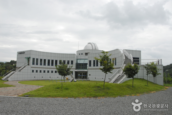
Center of Korea Observatory (국토정중앙천문대)
16.0 Km 14777 2021-08-12
127, Guktojeongjungang-ro, Yanggu-gun, Gangwon-do
+82-33-480-2586
The Center of Korea Observatory in Yanggu-gun is named for its location at the center of the Korean Peninsula. It is equipped with an 80-centimeter reflecting telescope. There is also an exhibition hall providing the most recent astronomy news, a planetarium showing the night sky, and a range of hands-on programs.
Gwangchi Recreational Forest (광치자연휴양림)
16.4 Km 25824 2021-03-25
265, Gwangchiryeong-ro 1794beon-gil, Yanggu-gun, Gangwon-do
+82-33-482-3115
Gwangchi Recreational Forest is located near Gwangchiryeong Pass (alt. 800 meters). The pass encompasses waterfalls and valleys in a dense forest. Gwangchi Tunnel connects the areas of Yanggu and Inje to the East Sea, making the forest a great addition to travel itineraries. The recreational area serves as a retreat for residents and helps to support the local economy through tourism.
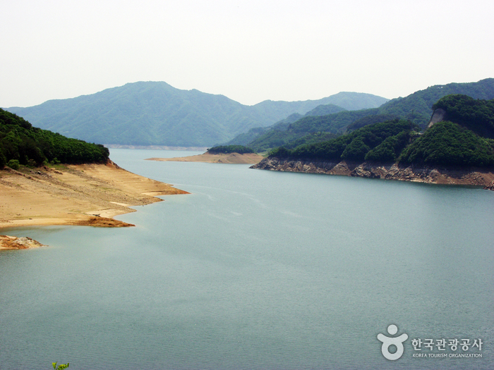
Soyangho Lake (Yanggu Section) (소양호(양구))
16.6 Km 9550 2023-09-14
Seokhyeon-ri, Yanggu-gun, Gangwon-do
+82-33-480-7204
Soyangho Lake is a man-made lake that was created when Soyang Dam, the biggest rock-filled dam in Asia, was built in 1973. The lake is a hotspot for aquatic tourism and the lakeside road is an important route that connects Chuncheon and Yanggu. It is also a popular fishing spot as over 50 types of fishes can be found.
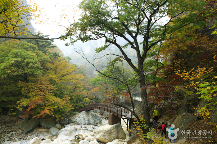
Seoraksan National Park (Southern Section) (설악산국립공원 (남설악))
17.5 Km 44281 2024-04-02
801 Seorak-ro, Yangyang-gun, Gangwon-do
Seoraksan Mountain, the highest amid the Taebaek Mountain Range, boasts beautiful landscape and scenery all year round. To the east of Hangyeryeong and Misiryeong Passes is classified as the outer section ("Oeseorak"), to the west is the inner section ("Naeseorak"); and to the south of Hangyeryeong Pass as the southern section ("Namseorak").
The southern section is famous for its mineral water, hot springs, and waterfalls including Yongsopokpo, Sibipokpo, and Yeosinpokpo Falls. Jeongbongsan Mountain (1,424.2 meters) is also included in the area. There are also several different hiking courses varying in distance and duration.
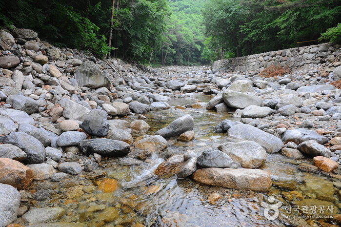
Sibiseonnyeotang (Tangsudonggyegok Valley) (십이선녀탕(탕수동계곡))
17.6 Km 9456 2021-02-24
Sibiseonnyeotang-gil, Inje-gun, Gangwon-do
+82-33-462-2554
Sibiseonnyeotang Valley (Valley of the Twelve Angels’ Bath) is a beautiful valley filled with water flowing through a cascade of waterfalls and pools. In the past, there were 12 of each, although the size and shape has changed over time. The valley also features many uniquely shaped rocks and a forest comprised of many types of trees, including maple, pine nut, and pine trees. The path passing through the V-shaped valley crosses the stream often, so visiting after heavy rainfall is not recommended.
Baekundonggyegok Valley (백운동계곡)
18.5 Km 7960 2019-12-05
Baekdam-ro, Buk-myeon, Inje-gun, Gangwon-do
+82-33-462-2554
Baekundonggyegok Valley flows 5 km from the valley of Deoktaesan Mountain and Seongaksan Mountain. There are oak trees and maple trees growing in thick clusters and clean waters flowing nearby.
Baekundonggyegok Valley stands between the seven brother stones and Yongdampokpo Falls, and starting from this point to Gwuiddegicheong Peak is Baekundonggyegok Valley. The rocks are connected in a long line and ponds can be seen here and there. On each side of the valley there are rock walls, which make for some unforgettable scenery. Baekundonggyegok Valley maintains its natural beauty and majesty, which attracts many hikers. Especially from the middle point where Jikbaekun and Gokbaekun combine to make the Gugokgyegok Valley the most magnificent scenery of Baekundonggyegok Valley can be seen. The largest waterfall of Baekundonggyegok Valley, called Baekunpokpo Falls, is about 30 meters high. The upper part of the waterfall has rocks lined up in a long line. The landscape of Seoraksan Mountain seen from this point is the representative landscape of the mountain.
 English
 한국어
한국어 日本語
日本語 中文(简体)
 Deutsch
 Français
 Español
 Русский