
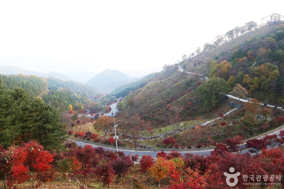
Hamyang Jianjae Pass (함양 지안재)
10.6 Km 0 2024-02-08
119-3 Guryong-ri, Hamyang-eup, Hamyang-gun, Gyeongsangnam-do
Jianjae Pass, renowned for its picturesque winding roads, is a celebrated attraction in Hamyang. It was also selected as one of the "100 Most Beautiful Roads in Korea." While the pass is navigable by car, it's best appreaciated by stopping to soak in the views from the observation deck. An observatory is situated at the end of Jianjae Pass, providing visitors with an excellent vantage point for capturing stunning photographs.
Road to Jirisan (지리산 가는길)
10.6 Km 0 2024-02-08
Jirisanganeun-gil, Hyucheon-myeon, Hamyang-gun, Gyeongsangnam-do
Road to Jirisan is a 12 km road from Hamyang-eup to the vicinity of Jirisanjeilmun Gate. You go through Jianjae Pass and Odojae Pass to Macheon, where you will find Jirisanjeilmun Gate and Jirisan View Park. From here, you can see the entire ridge of Jirisan Mountain, and there are also hiking trails to Beophwasan Mountain and Sambongsan Mountain. The road is also renowned for its biking trails and attracts many motorcycle enthusiasts.
Anui Wonjo Galbijip (안의원조갈비집)
10.8 Km 19030 2024-02-23
127-2 Gwangpung-ro, Anui-myeon, Hamyang-gun, Gyeongsangnam-do
055-962-0666
Located near Anui-myeon Bus Terminal, Anui Wonjo Galbijip specializes in hanu galbi (Korean beef galbi). Designated as a local specialty restaurant by Hamyang County, its signature dish is hanu galbijjim (braised Korean beef galbi), known for its tender meat and flavorful soup. Additionally, it's a delicacy to stir-fry the leftover galbijjim (braised galbi) with kimchi and rice.
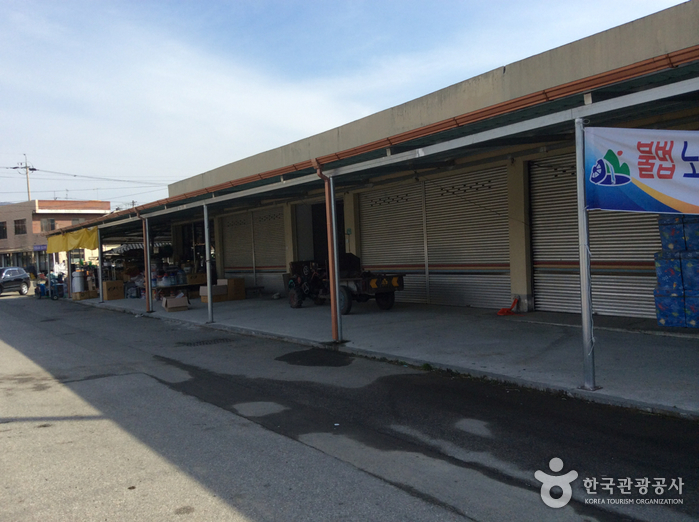
Anuijang Market (5th & 10th Day Market) (안의장 (5, 10일))
10.9 Km 10603 2024-01-08
25-10 Yakchosijang-gil, Anui-myeon, Hamyang-gun, Gyeongsangnam-do
As a traditional fifth-day market, this market started in 1948 in Seokcheon-ri, Anui-myeon, Hamyang-gun. Anui-myeon is a transportation hub connecting the surrounding areas such as Geochang and Hamyang, and many merchants gather from nearby areas on the 5th and 10th (5th, 10th, 15th, 25th, and 30th) every month when the market is held. There are plenty of things to see as the merchants sell local specialties and fresh produce in season, such as homegrown apples, strawberries, watermelons, dried persimmons, garlic, and vegetables. At a native herb market building, customers can find excellent medicinal herbs from Hamyang at a low price, making it fun to look around. Visitors can also enjoy hearty meals such as sundae gukbap (sundae and rice soup) and galbi tang (galbi soup), as well as delicious street foods and donuts.
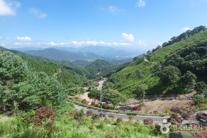
Odojae Pass & Jirisan View Park (오도재와 지리산조망공원)
14.2 Km 43126 2024-02-08
534 Jirisanganeun-gil, Macheon-myeon, Hamyang-gun, Gyeongsangnam-do
Established as the most direct route from Hamyang to Jirisan in 2004, Odojae Pass has gained recognition not only as a thoroughfare but also for its serpentine path winding through the pass. Positioned just below the summit of Odojae Pass, the expansive Jirisan View Park offers a panoramic view of Jirisan Mountain's main ridge (Nogodan Peak to Cheonwangbong Peak). This park provides a spectacular vista of Jirisan Mountain and a peaceful rest area for travelers navigating Odojae Pass.
Birthplace of Nongae (논개생가)
14.9 Km 15425 2024-04-07
558, Uiam-ro, Jangsu-gun, Jeonbuk-do
+82-63-350-1636
Nongae was born in Juchon Village in the 7th year of King Seonjo (September 3, 1575). A clever and beautiful young lady, Nongae voluntarily registered as a gisaeng (female entertainer) at the age of 19 when the nation was at risk of invasion during the Imjin War. While entertaining one evening, she led Japanese general Keyamura Rokusuke to the edge of a cliff and flung her arms around him, casting both herself and the general to their deaths in the Jinju Namgang River.
To commemorate her faithfulness and allegiance to her country, a project to restore her place of birth was completed in September 2000, drawing many visitors. Nearby Nongae’s birthplace are many tourist attractions, including Deogyusan Mountain and Odongje Pass and a hiking trail that connects Jangansan County Park, Jijigyegok Valley, and Donghwa Dam.
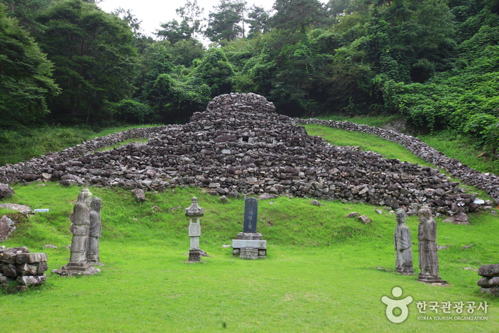
Tomb of King Guhyeong, Sancheong (산청 전 구형왕릉)
15.2 Km 18145 2020-06-30
Guhyeongwangneung-ro, Sancheong-gun, Gyeongsangnam-do
+82-55-970-6411
This stone grave is known to be the tomb of King Guhyeong, the 10th King of the Gaya Kingdom. He is also known as King
Guhae or King Yang, and is the grandfather of Kim Yoo Shin. Since becoming
the King of Gaya in 521 AD, he reigned for 11 years until he handed over his
country to King Beopheung of the Silla Kingdom in 532 AD.
There are two
different scholarly opinions about this tomb. One is that it should be classified as a stone pagoda and the
other, a royal tomb. The reason why this was regarded as a pagoda is
that there are similarly shaped stone pagodas in the Andong and Uiseong regions.
The basis for it being called Wangreung, or royal tomb, is that there is a record in Dongguk Yeoji Seongram (an
ancient history book published during the rule of King Seongjong in the Joseon dynasty) and
in Saneum-hyeon Sancheonjo (a record of events in the region) of it being a
tomb. The
notes state that "there is a structure with steps on
the four faces, in the form of nine dragons piled up of stones at a distance
of about 16 km (40 ri in traditional Korean scale) from the village, so
people believe it must be a royal tomb".
The record describing the name of the king buried
in this tomb can be extracted from a record of travels called Wangsan Shimreunggi
written by Hong Ui Young, a Joseon dynasty scholar. In addition, there’s also
an entry in Wangsansagi, a book on the history of Wangsansa Temple (a
temple located west of the tomb) that the person buried in the tomb is King Guhyeong.
Unlike ordinary
graves, the tomb is built at the middle part of the hill's slope. The tomb
has a unique appearance made up of steps and layers, with the highest point
being 7.15 meters high. There are seven layers at the front and no steps at
the back due to it being built on an inclined surface. The overall shape of
this tomb is different from the pyramids built on level ground. The top of the tomb is oval in
shape. At the center, there is a stone tablet with the words "Royal Tomb of King Yang of the
Garak Nation". In front of the tomb, there are several stone pieces that
have been added to the original tomb.
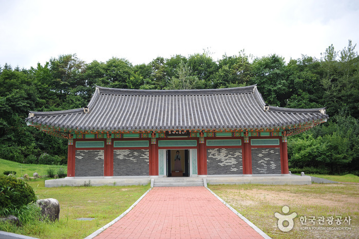
During the 17th Year of King
Jeongjo of the Joseon dynasty (1793), a wooden box that was passed down from generation
to generation in Wangsansa Temple was discovered. The box contained portraits
of King Guhyeong and his queen, their clothes, an archery bow, and other objects. To
preserve these, a royal building called Deogyangjeon Hall was
constructed. To this date, a memorial service is held here in spring and
autumn of every year.
![[Jirisan Trail Course] Inwol-Geumgye](http://tong.visitkorea.or.kr/cms/resource/73/1918173_image2_1.jpg)
[Jirisan Trail Course] Inwol-Geumgye
15.5 Km 5195 2024-04-06
308-1 Junggun-ri, Inwol-myeon, Namwon-si, Jeonbuk-do
Inwol-Geumgye Trail Course is part of the Jirisan Trail, starting from Inwol-myeon, Namwon-si, Jeollabuk-do, and passing through Deunggujae in Hamyang-gun, Gyeongsangnam-do, before reaching the village of Geumgye. Covering a distance of 20.5 kilometers, completing the trail typically takes around 10 hours, leading many travelers to plan a 1-night, 2-day itinerary. Along the way, hikers can enjoy the majestic landscapes of Jirisan Mountain, vast rice paddies, and visit six mountain villages.
Jangansan County Park (장안산군립공원)
16.5 Km 14288 2024-04-07
Jangan-ri, Jangsu-gun, Jeonbuk-do
+82-63-350-2445
Situated in Jangsu-gun in Jeollabuk-do, Jangansan Mountain (alt. 1,237 m) was officially designated a county park in 1986. Deoksan Valley Stream, which originates in the southwestern part of Jangansan Mountain and flows into Yongnimcheon Stream, is famous for the Deoksanyongso Waterfall Basins and the 20 or so large rocks that dot its banks. The sprawling fields of reeds along the East Ridge are also a major draw, undulating like waves of gold in the crisp autumn wind. In particular, the east hiking path on Jangansan Mountain is lined with a wide field of silver grass making it popular among hikers.
Banghwadong Recreational Forest (방화동 자연휴양림,가족휴가촌)
16.7 Km 6039 2024-04-07
778, Banghwadong-ro, Jangsu-gun, Jeonbuk-do
+82-63-350-2474
Banghwadong Recreational Forest is located at the foot of Jangansan Mountain. The mountain trail from Deoksanyongso Pond leading to Banghwadonggyegok Valley features nature learning centers and adventure games facilities. The clean valley is lined with oddly shaped cliffs, shrubs and trees, which all combine into a splendid view. The forest is situated at a highland more than 500 meters above sea level. It is surrounded by mountains that are over a thousand meters above sea level, so the temperature is low and the water at the valley is cool even in the summer.
There are log cabins, group accommodation facilities, and training halls by the valley to accommodate group visits, conferences, gatherings and seminars. The recreational forest also operates Banghwadong Family Vacation Village for family visitors, equipped with accommodation facilities, various camping sites, and a wood carving experience center.
 English
 한국어
한국어 日本語
日本語 中文(简体)
 Deutsch
 Français
 Español
 Русский