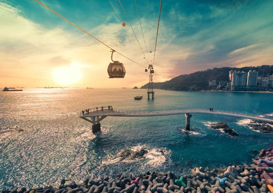
Busan Air Cruise (부산 송도해상케이블카)
14.1Km 2025-10-24
171 Songdohaebyeon-ro, Seo-gu, Busan
Busan Air Cruise was built to revive the reputation of Songdo Beach, the first public beach in Korea opened nearly 30 years ago. Thirty-nine cabins, including crystal cabins with transparent floors, travel over the ocean between Songnim Park on the east and Amnam Park on the west. Visitors can also enjoy the first cable car museum in the nation at Songdo Doppelmayr World, Asia's first midair swing Sky Swing, theme park photo services and more.
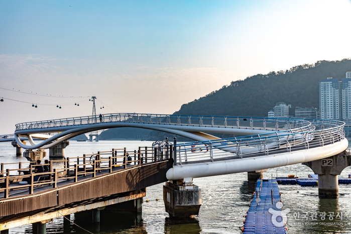
Songdo Cloud Walk (송도 구름산책로(스카이워크))
14.3Km 2025-04-15
129-4 Amnam-dong, Seo-gu, Busan
Songdo Cloud Walk is located on the eastern side of Songdo Beach, connecting to Geobukseom Island. The skywalk features sections with a clear glass floor that creates the feeling of walking on top of the ocean. The amazing panoramic view of the surrounding area has made the skywalk a popular destination. First opened in 2015, the 365-meter-long skywalk continues to attract tourists to Songdo Beach.

Barog Clinic (Deokcheon) (바로그의원 (덕천))
14.3Km 2025-09-23
4th Floor, 24 Mandeok-daero, Buk-gu, Busan
Barog Clinic (Deokcheon), first opened as Yeppeuda Clinic, has steadily expanded over the past seven years and is now recognized as a reliable provider of high-quality medical services. With a facility of 684 square meters and a team of 25 professionals, we deliver customized, patient-centered treatments that have earned the confidence of our patients. An average of 200–250 patients visit the clinic daily, and our foremost strength is their satisfaction. Led by seasoned medical staff with more than 10 years of experience, we provide the most effective treatment methods tailored to each individual, resulting in a high rate of return visits. In addition, we continue to invest in advanced medical equipment and always strive to build lasting trust with patients through communication and consideration.
Olive Skin Clinic (올리브피부과의원)
14.3Km 2025-10-23
6th Floor, 3 Mandeok-daero 27beon-gil, Buk-gu, Busan
Olive Skin Clinic is a specialized dermatology clinic located in Busan. The clinic is specialized in lifting, anti-aging, pigmentation disorders, acne, and scar treatments. At our clinic, dermatology specialists directly handle consultations and treatments, ensuring safe and accurate dermatological procedures. Especially in the fields of lifting and anti-aging, the clinic offers effective and highly satisfactory results through years of experience and numerous cases.
SMB Wellness (에스엠비 웰니스 센터)
14.4Km 2025-10-23
34, Hangnideungdae-ro, Ilgwang-eup, Gijang-gun, Busan
Nestled in a quiet seaside village in Gijang-gun, Busan, SMB Wellness is a place dedicated to restoring balance between the soul, mind, and body. True to its name, the center pursues holistic recovery, offering a chance to step away from the rush of daily life and regain your inner self. SMB Wellness is a restorative space for those seeking true renewal, beyond temporary healing. Take time to fully focus on yourself and breathe new life into your weary body, mind, and soul.
Kosin University Gospel Hospital (고신대학교복음병원)
14.4Km 2025-10-23
262 Gamcheon-ro, Seo-gu, Busan
Kosin University Gospel Hospital practices the love of Jesus Christ by providing patient-centered care, spreading the gospel, and training medical students.
We are committed to the health and well-being of our patients.
Founded as Gospel Clinic in Yeongdo, Busan, in 1951 during the Korean War, we opened the region's first cancer center in 1978. For over 70 years, we have provided distinguished medical services guided by Christian values.
We lead the region’s healthcare industry, guided by our core values: innovation and self-direction, recovery and future orientation, communication and mutual trust, and love and goodness. As a tertiary hospital at the top of the healthcare delivery system, we treat severe diseases at our cancer center founded in 1978. We also opened the region's first advanced robotic surgery training center, inspired by Dr. Jang Gi-ryeo, to train both Korean and international medical professionals. Additionally, we are committed to innovative treatments by introducing AI-based medical technologies, aligning with the 4th Industrial Revolution.
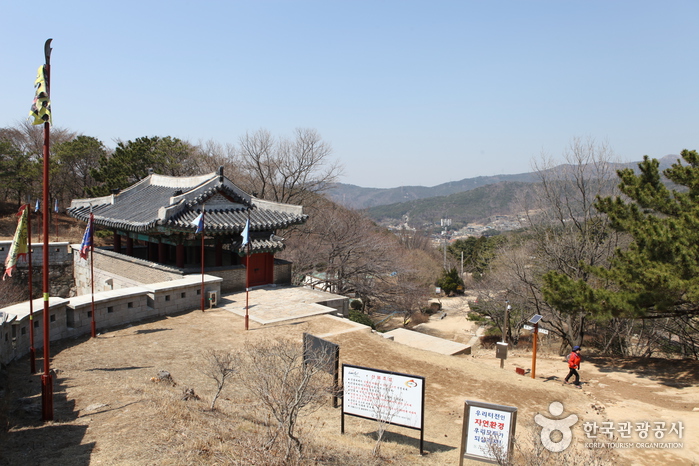
Geumjeongsanseong Fortress (금정산성)
14.5Km 2024-03-05
78-5 Bungmun-ro, Geumjeong-gu, Busan
Geumjeongsanseong Fortress, with a circumference of 18,845 meters along the ridges and valleys of Geumjeongsan Mountain, is a large-scale fortress built during the Joseon dynasty between 1701 and 1703. The fortress is accompanied by Geumjeongsanseong Village and is known for producing Sanseong makgeolli (unrefined rice wine), a traditional Korean alcoholic beverage. Additionally, there are numerous restaurants, cafés, and attractions, making it a place where nature, history, cuisine, and sightseeing coexist.
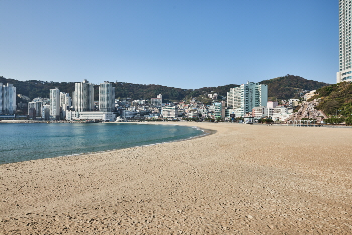
Busan Songdo Beach (부산 송도해수욕장)
14.8Km 2024-04-26
100 Songdohaebyeon-ro, Seo-gu, Busan
Songdo Beach is 800 meters long and 50 meters wide. The average water level is 1~1.5 meters. It was one of the first beaches to open in Korea in 1913. In 2000, the beach underwent a comprehensive 5-year reconstruction and reopened with restored and expanded coastlines and the addition of several fountains. Nearby attractions include Busan’s famed Jagalchi Seafood Market and Amnam Park. Amnam Park was a military protected area that opened to the public as a nature park in April 1996. Amnam Park, as well as Dudo Park, a famous sea fishing spot, connects to Songdo, where visitors can see a spectacular landscape with seagulls, a symbol of busan, and the quiet seascape with Yeongdo Island in the distance.
The area has a variety of accommodation and dining options, and is well equipped with convenience facilities such as an overpass, promenade, boat yard, and parking lot. Amnam Park on the Songdo coast is a coastal ecological park. It has an observatory, a 3.8-kilometer promenade, a roadside cafe, and raw fish restaurants with a panoramic view of the Songdo coast and Busan Namhang Port. Another historically important attraction in the area is the Provisional Capital Memorial Hall that was used as the presidential residence for three years when Busan was the temporary capital during the Korean War.
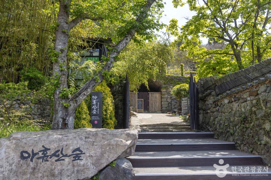
Ahopsan Forest (아홉산숲)
15.1Km 2025-10-23
37-1 Midong-gil, Gijang-gun, Busan
Ahopsan Forest is a forest located at the foot of Ahopsan Mountain in Cheolma-myeon, Gijang-gun, Busan. It is a place where visitors can meet the undamaged natural environment and ecology. Diverse forests ㅡsuch as bamboo forests, cypress forests, cedar trees, ginkgo trees, and natural forests, including Geumgang pine trees aged 100 to 300 years, make up Ahopsan Mountain. It is a private forest with a total area of 520,000 square meters and has been there for about 400 years. Only a limited number of people who have made a reservation in advance are allowed to enter for nature conservation. Unlike amusement parks and recreation areas, viewing is possible only within the limits that do not damage nature. However, forest experiences, activity programs for children, and forest explanation program are offered for visitors' entertainment.
Sondo Yonggung Suspension Bridge (송도용궁구름다리)
15.3Km 2022-03-25
620-53, Amnam-dong, Seo-gu, Busan
Sondo Yonggung Suspension Bridge connects the renovated Songdo Cloud Bridge from Songdo Beach to Geobukseom Island and extended from Amnam Park to Dongseom Island. Visitors can enjoy the thrill of walking above the waters while enjoying the beautiful view in this 127 meters long bridge.
 English
 한국어
한국어 日本語
日本語 中文(简体)
 Deutsch
 Français
 Español
 Русский