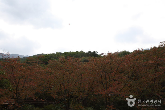
Sinbulsan County Park (신불산군립공원)
6.0 Km 23507 2021-06-30
Sangbuk-myeon, Ulju-gun, Ulsan
+82-52-229-7882
Sinbulsan County Park is located in parts of the Sangbuk and Samnam districts of Ulju County. The massive area encompasses 11.66 square kilometers and is home to one of the most impressive peaks in the Yeongnam Mountain Range found in the southeast of Korea. The park’s hiking trails interconnect with those of neighboring Gangwolsan and Yeongchwisan Mountains and attract a large number of hikers year-round.
Near the peak of Silbulsan Mountain sits a fortress with breathtaking views of silver grass. Water starts high above the clouds at Danjobong Peak and trickles down through streams and waterfalls to join the deep mountain valleys. One of the better known attractions in Silbulsan Mountain is Hongnyupokpo Falls which offers impressive views from its gentle cliffs.
Also nearby the mountain are Deungeok Hot Springs and a number of restaurants for hikers to visit and enjoy after a full day on the mountain.
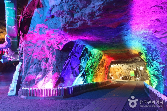
Amethyst Cavern Park (자수정동굴나라)
6.3 Km 105568 2022-09-06
212, Jasujeong-ro, Ulju-gun, Ulsan
+82-52-254-1515
Amethyst Cavern Park is the largest man-made cave tourist attraction in Korea, where one of the five jewels of the World, amethyst, was mined. Connected like a labyrinth, the cave is 2.5 kilometers long and fills an area of approximately 15,000 square meters. The average temperature is between 12 and 16 degrees Celsius year round. Visitors can take either the walking tour that goes through a different themed halls or take a boat ride through the cave river. On the second floor of the cave, visitors can see Jurassic World filled with different dinosaurs and character lamps.
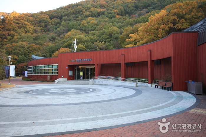
Ulsan Petroglyph Museum (울산암각화박물관)
6.6 Km 34628 2021-02-22
254, Bangudaean-gil, Ulju-gun, Ulsan
+82-52-229-4797
Ulsan Petroglyph Museum was established on May 30, 2008 at the entrance to Petroglyphs of Bangudae Terrace (National Treasure No. 285) in Ulju-gun. The museum displays 311 exhibit materials and has an exhibition hall, a storage room, a research lab, and an audiovisual room.
The exhibition hall presents models of petroglyphs of Bangudae and petroglyphs of Cheonjeon-ri (National Treasure No. 147), an educational video introducing the petroglyphs, a children’s hall, and family activity facilities. Visitors can observe reproductions of famous petroglyphs at the outdoor exhibit.

Ulsan Daegok Museum (울산대곡박물관)
6.7 Km 38509 2021-05-18
257, Seohacheonjeon-ro, Ulju-gun, Ulsan
+82-52-229-4787
Ulsan Daegok Museum displays artifacts that were uncovered from the area of Daegok-ri during the construction of Daegok Dam. Approximately 13,000 relics were excavated during land inspection prior to the dam construction, including Hasamjeong Ancient Tomb. These findings were collected and became available for public display when the museum opened on June 24, 2009.
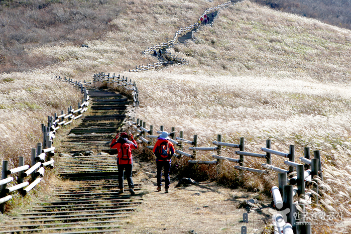
Ganwolsan Mountain (간월산)
6.8 Km 14639 2021-06-30
614, Ganwolsan-gil, Ulju-gun, Ulsan
+82-52-277-0101
Ganwolsan Mountain is a popular destination for hikers in the Ulsan and Busan area as well as other regions of Gyeongsangnam-do. In early August, the reeds and lilies near the summit create a splendid view. To the west, the deep Naerijeong and Wangbonggol Valleys channel clean water to Baenaegol Pass.
From the Ganwolgogae Pass, hikers can follow the Singal Path to Wanbonggol Pass towards Paraeso Falls. There, visitors will find a cave called Jungnimgul, which is sacred Catholic ground often visited by the Catholic faithful. The first church built by Catholics in the Yeongnam region to escape persecution is found in Buldanggol Pass in Ganwolsan Mountain area. The tomb of Kim Agatha who died in persecution is also in the Ganwolgol Valley.
Petroglyphs of Bangudae Terrace (울주 대곡리 반구대 암각화)
7.2 Km 26550 2023-07-17
285, Bangudaean-gil, Ulju-gun, Ulsan
+82-52-204-0322
In Daegok-ri, Eonyang-eup sits Bangudae Terrace, a picturesque spot where a ridge of Yeongosan Mountain extends to and stands tall to form quite a spectacle featuring uniquely shaped rocks and cliffs. The name, Bangudae, comes from how it resembles a turtle lying prone on the ground. Petroglyphs are paintings drawn by people from the prehistoric times carved on rocks and depicting various scenes and events in their daily lives. Petroglyphs were often drawn on enormous rocks and other sacred locations of groups, and it is believed that people gathered around them to hold various rituals.
Petroglyphs of Bangudae Terrace in Daegok-ri, Ulju-gun are estimated to have been drawn over several periods since the New Stone Age so you can discover the differences in styles among various ages. Primary objects that were popularly carved include sea animals, land animals, humans and tools and, as our prehistoric ancestors actively engaged in hunting, the hope of abundance in game is believed to be the reason why these objects were frequently carved on rocks. Vividly expressing animals and hunting scenes and colorfully depicting outstanding traits of objects, these petroglyphs are a form of both hunting art and religious art, and they are considered as the greatest masterpieces from which we can take a peek at the life and customs of the prehistoric ages.
Petroglyphs of Cheonjeon-ri, Ulju (울주 천전리 각석)
7.3 Km 30009 2020-02-05
Cheonjeon-ri, Dudong-myeon, Ulju-gun, Ulsan
+82-52-277-0101
Petroglyphs refer to the paintings in which objects and symbols are carved, pecked, and colored on rocks, huge cliffs and cave walls.
Some of these rocky paintings are from as early as the late Paleolithic Era, but mostly they are seen from the New Stone Age, Neolithic Era and Bronze Age in which times these paintings were abundant.
The upper part of the rock shows various animals including deer pecked into the rock, and the lower part of the rock has writing and drawings of humans, and animals made by penciling.
As for the upper part, it is thought to have been made throughout the New Stone Age and Bronze Age to express their consciousness for abundance. In comparision, the painting of a cavalcade, a sailing boat, a dragon, a horse, and a deer and about 300 writings on the lower part of the rock were considered to be done by people during unified Silla, showing their belief of the area as a holy ground.
Unmunsan National Recreational Forest (국립 운문산자연휴양림)
8.2 Km 169589 2021-07-16
763, Unmun-ro, Cheongdo-gun, Gyeongsangbuk-do
+82-54-371-1327
Unmunsan National Recreational Forest in Cheongdo, Gyeongsangbuk-do is located at the foot of Unmunsan Mountain (1,188 meters), which is also called Hogeosan Mountain. It is a great place to spend time in summer for hiking and camping, surrounded by taller mountains (more than 1,000 meters above sea level) such as Munboksan Mountain (1,014 meters) and Gajisan Mountain (1,240 meters).
Yongmipokpo Falls (20 meters) and Byeokgyesu Valley, in which the waters flow across the sandless rock bed, are famous locales in the forest. Located in a thick broadleaf forest, inhabited by many diverse species such as Korean mountain camellia, Unmunsan National Recreational Forest offers lush greenery in summer, beautiful foliage in autumn, and cozy, splendid snowscapes along with the Yongmi Ice Wall in winter. In Unmunryeong, located 2.5 kilometers to the east, visitors can watch the spectacular sunrise above the East Sea.
Hobaksogyegok Valley (호박소계곡)
9.1 Km 45170 2020-07-10
334-1, Eoreumgol-ro, Miryang-si, Gyeongsangnam-do
+82-55-359-5361
Hobaksogyegok Valley is located within Gajisan Mountain approximately 3 kilometers away from Eoreumgol Valley in Jaeyaksan Mountain, where the water originates. The valley offers beautiful surroundings and clear water developed over the years. Hobakso Pond, shape like a grain-grinding tool, is located at the base of a 10-meter-high waterfall. With a circumference of 30 meters, the pond is also called Sirye Hobakso Pond, Guyeongpokpo Falls, and Baengnyeonpokpo Falls. In the past, the pond was a spiritual place where people would pray for rain. Surrounded by white granite rocks, the area is a scenic place of natural beauty, free from pollution. Visitors can also look around nearby Baengnyeonsa Temple, Hyeongjeso Pond and Ocheonpyeong Rock.

Paraesopokpo Falls (파래소폭포)
9.4 Km 24333 2021-06-16
200-78, Eoksaebeol-gil, Ulju-gun, Ulsan
+82-52-254-2123
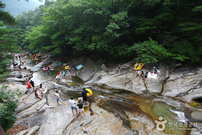
Paraesopokpo Falls is located in Baenaegol Valley, connected to the foothills of Ganwolsan and Sinbulsan Mountains. The falls and surrounding valley are a popular attraction during the summer among vacationers and hikers eager to escape from the summer heat. The falls' water flows into Baenaecheon Stream, which later merges with the Nakdonggang River.
 English
 한국어
한국어 日本語
日本語 中文(简体)
 Deutsch
 Français
 Español
 Русский