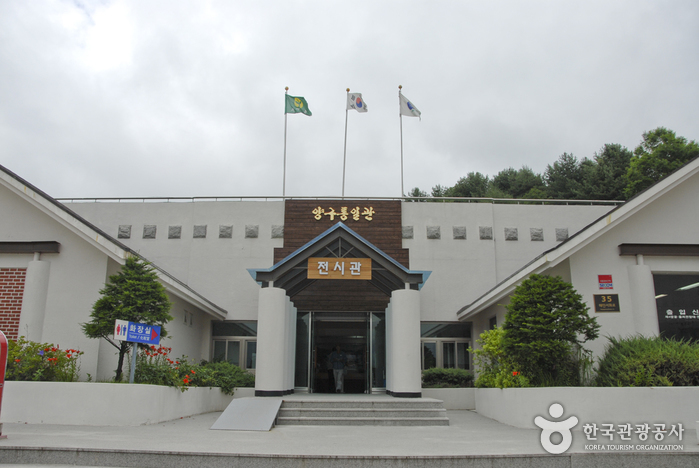
Yanggu Unification Hall (양구통일관)
.0M 2021-09-10
35, Haeanseohwa-ro, Yanggu-gun, Gangwon-do
The Yanggu Unification Hall is located in the northernmost part of the Civilian Control Zone in Haean-myeon, Yanggu-gun. It was built and opened to be utilized as a unification education center that would help broaden people’s understanding about the real situation in North Korea in preparation for reunification and encourage commitment for reunification. The location is 5 kilometers away from The 4th Tunnel, in the northern end of the punch bowl basin and it first opened in 1996. It has a first exhibition hall, second exhibition hall, agricultural specialty market, and a parking lot that can accommodate about 100 vehicles.
Directly operated by Yanggu-gun District Office, the Yanggu Unification Hall displays materials that show the reality of North Korea including household goods, exports and photographs. The agricultural specialty market sells agricultural goods, North Korean products, and tourism souvenirs. Located nearby are The 4th Tunnel, Eulji Observatory, and War Memorial Museum in Yanggu. Eulji Observatory is the northernmost located observatory in South Korea. The 4th Tunnel is the only tunnel among the four tunnels dug by North Korea that operates electric cars, allowing visitors to travel inside. The War Memorial Museum in Yanggu was built to shed new light on the nine battles fought in Yanggu during the Korean War. The Yanggu Unification Hall deals with works related to the Eulji Observatory, The 4th Tunnel and War Memorial Museum in Yanggu.

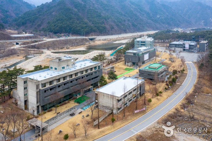
Yanggu War Memorial Hall (양구전쟁기념관)
.0M 2022-10-14
35, Haeanseohwa-ro, Yanggu-gun, Gangwon-do
Opened June 20, 2000, the Yanggu War Memorial Hall was built to commemorate the sacrifice and heroism of those who fought during the Korean War at the nine battlefields located in Yanggu: Dosolsan, Daeusan, Bloody Ridge, Baekseoksan, Punch Bowl, Gachilbong, Danjang Ridge, 949 Hill, and Christmas Hill. The museum also reminds the current and future generations of the real cost of war and the sacrifices that were made.
The exhibition hall is divided according to themes: freedom, welcoming, meeting, understanding, experience, assurance, tribute, rooftop, and contemplation. Exhibition facilities include a high-quality imaging system and a three-way multi-imaging room that combines battle scene dioramas, videos, and slides.
Eulji Observatory (을지전망대)
37.2M 2022-10-14
621, Hu-ri, Haean-myeon, Yanggu-gun, Gangwon-do
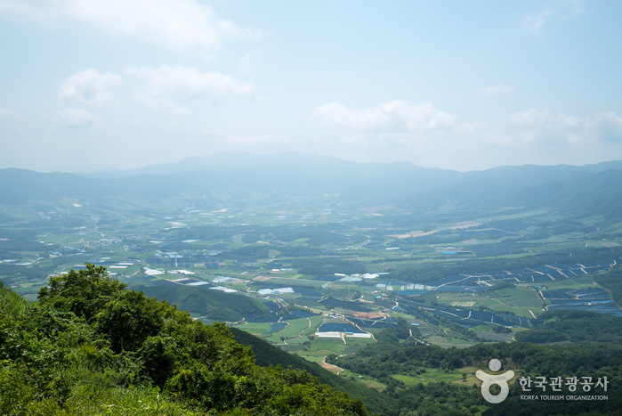
Eulji Observatory, located near the Military Demarcation Line along the ridge of Gachilbong Peak, is now one of the most informative sites dating back to the Korean War. From Eulji Observatory, visitors can see North Korean land from afar as well as Birobong Peak of Geumgangsan Mountain. It is the northernmost DMZ attraction and over 100,000 people visit this observation platform every year.
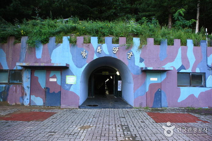
The 4th Tunnel (제4땅굴)
4.8Km 2022-10-14
Ihyeon-ri, Yanggu-gun, Gangwon-do
The 4th Tunnel was discovered on March 3, 1990. It is located 1,200 meters from the Military Demarcation Line in the demilitarized zone of South Korea. This is the only tunnel to be discovered that provides full access to tour groups. Educational instruction is given in the square outside the tunnel.
Yanggu Eco-Botanical Garden (양구생태식물원)
12.5Km 2022-08-18
169, Sumgol-ro 310beon-gil, Yanggu-gun, Gangwon-do
First opened in June 2004, Yanggu Eco-Botanical Garden was built on a total area of 189,141 ㎡. Nearly 3.1 billion Korean won (approximately 3 million USD) was spent on the construction and it was built to be developed into a South and North Korean ecosystem restoration center. Located in the northernmost region of South Korea, it houses more than 400 rare plants including plants that are Korean native species and protected by Korean Ministry of Environment.
The garden is divided into six parts by their features including a botanical garden, natural forest, and facilities zone. In the botanical garden, rare plants such as northern native plants and alpine plants that are naturally grown in the demilitarized zone (DMZ) and Yanggu area are displayed in one place.
There are also walking trails, a medicinal plants exhibition hall, plant nursery, and greenhouse. To add a natural and lively touch to the garden, a mountain stream zone and wetlands zone were prepared to provide people with the chance to enjoy the pleasant sound of running water.
Yongneup Marsh of Daeamsan Mountain (Gangwon Peace Area National Geopark) (대암산 용늪 (강원평화지역 국가지질공원))
12.7Km 2024-02-22
1106-27 Geumgang-ro, Seohwa-myeon, Inje-gun, Gangwon-do
Daeamsan Mountain is a rugged peak composed of rocks, reaching an altitude of 1,304 meters from the foothills to the summit. Formed in the hilly area on the southwest slope, Yongneup Marsh harbors both northern and southern plant species, housing various rare flora and fauna amidst its exceptional natural landscape. Exploring the ecology of Yongneup Marsh is possible through guided tours, including the Seoheung-ri course (three times a day, five hours) and the Gaa-ri course (once a day, three hours). Identification is required, and reservations are mandatory, with the presence of guides accompanying visitors.
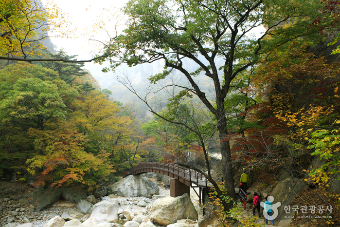
Dutayeon Valley [National Geopark] (두타연 (강원평화지역 국가지질공원))
15.3Km 2021-07-17
Gobangsan-ri, Yanggu-gun, Gangwon-do
Dutayeon Valley is located north of the Civilian Control Line, requiring advance reservation through the Yanggu-gun Office website as well as filling out admission information at the Dutayeon Gallery before entering the area with a guide. The valley has a waterfall located along Sataecheon Stream where it merges with Suipcheon Stream. The water falls into a plunge pool, which has also carved out a deep cave in the bedrock at the base of the waterfall.
Seoraksan National Park (Southern Section) (설악산국립공원 (남설악))
18.4Km 2024-04-02
801 Seorak-ro, Yangyang-gun, Gangwon-do
Seoraksan Mountain, the highest amid the Taebaek Mountain Range, boasts beautiful landscape and scenery all year round. To the east of Hangyeryeong and Misiryeong Passes is classified as the outer section ("Oeseorak"), to the west is the inner section ("Naeseorak"); and to the south of Hangyeryeong Pass as the southern section ("Namseorak").
The southern section is famous for its mineral water, hot springs, and waterfalls including Yongsopokpo, Sibipokpo, and Yeosinpokpo Falls. Jeongbongsan Mountain (1,424.2 meters) is also included in the area. There are also several different hiking courses varying in distance and duration.
Manhae Village (만해마을)
19.0Km 2021-07-29
91, Manhae-ro, Inje-gun, Gangwon-do
Manhae Village was established as a training center and memorial hall for national activist Monk Manhae Han Yongun, revered for his literary and philosophical inspiration, as well as his devotion to the nation and Korean people during the Democracy Movement.
Yanggu Porcelain Museum (양구백자박물관)
19.5Km 2022-08-09
5182, Pyeonghwa-ro, Yanggu-gun, Gangwon-do
Yanggu Porcelain Museum (formerly Bangsan Porcelain Museum) exhibits white porcelain from the Bangsan area, along with its collection and tools. There are also various visual aids that help understand the history of porcelain in the Bangsan area. The experience room is equipped with electric kilns, gas kilns, and firewood kilns, and is a facility for both outdoor and indoor experiences. Here, visitors can experience the entire process of making clay, molding, and baking it in a kiln. Bangsan-myeon, Yanggu was already well-known for pottery production since the Goryeo dynasty. During the Joseon dynasty, raw materials were supplied to the Gwangju branch in Gyeonggi-do, and here the technology and aesthetics spread to Gwangju.
 English
 한국어
한국어 日本語
日本語 中文(简体)
 Deutsch
 Français
 Español
 Русский