
Jecheon Oksunbong Suspension Bridge (제천 옥순봉 출렁다리)
10.6 Km 0 2022-04-08
342, Oksunbong-ro, Jecheon-si, Chungcheongbuk-do
+82-43-641-6738
Near one of Korea's Scenic Spot, Oksunbong Peak, Oksunbong Suspension Bridge provides visitors with a thrill stretching 222 meters long, 1.5 meters wide. The Deck Road and trekking trail made of palm tree mat completes the total length of 944 meters. Visitors can also easily get to Cheongpungho Lake and Oksunbong Peak.
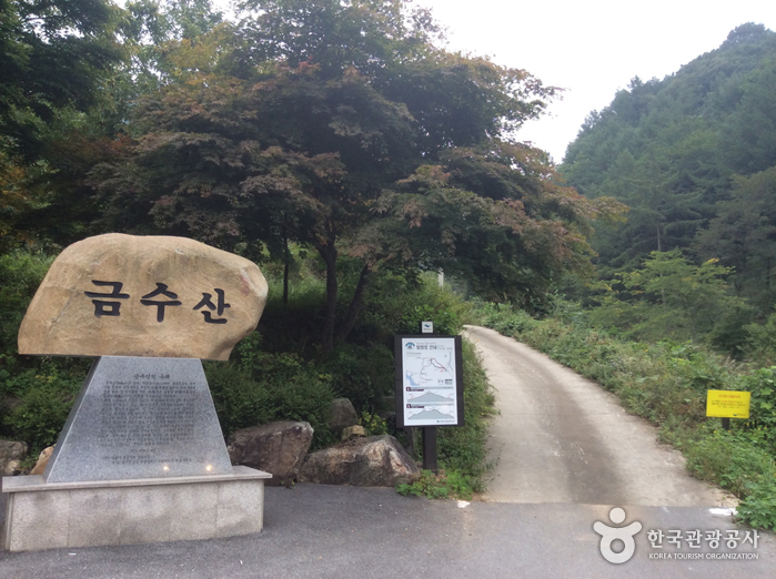
Geumsusan Mountain (금수산)
11.0 Km 38496 2021-05-28
210, Sanghak 1-gil, Danyang-gun, Chungcheongbuk-do
+82-43-653-3251
Geumsusan Mountain, originally called Baegamsan Mountain, was renamed by noted Joseon-period scholar Yi Hwang (pen name Toegye) when he was the chief governor of Danyang County, saying its graceful features matched the fineness of silk embroidery. The mountain is beautiful throughout the year with bright foliage in fall and an ice cave that stays frozen until early April. The view from the summit of the mountain resembles a pregnant woman lying on her side, and there is a legend that women who pray for a son here will have their wish come true.
Gudambong Peak & Oksunbong Peak (구담봉 & 옥순봉)
12.1 Km 42762 2020-06-11
Janghoe-ri, Danseong-myeon, Danyang-gun, Chungcheongbuk-do
+82-43-422-1146
Gudambong Peak and Oksunbong Peak (alt. 372m) are widely known as two of the “Eight Scenic Views of Danyang." Gudambong Peak (lit. Turtle Pond Peak) gets its name from the reflection of its rugged cliffs on the lake below, which is said to look like a turtle. Oksunbong Peak (lit. Bamboo Shoot Peak), well known for its magnificent scenery, was so named because its white and mossy rocks stand high like fresh bamboo shoots.
The historic book Yeojiseungnam (Geographical Survey of Korea) describes how Kim Il-son, a civil officer in the Joseon Dynasty, greatly extolled the beauty of its marvelous ravines. Both Gudambong Peak and Oksunbong Peak offer spectacular views of Chungjuho Lake and Geumsusan Mountain.
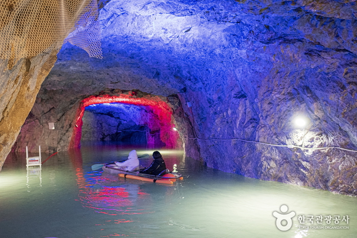
Chungju Hwarokdonggul Cave (충주 활옥동굴)
12.1 Km 0 2023-12-22
26, Mokbeoran-gil, Chungju-si, Chungcheongbuk-do
Developed in 1922 during the Japanese Forced Occupation, this is the only talc mine in Korea and is the largest in the East, with a recorded length of 57km, an unofficial length of 87km, and an underground vertical x_height of 711m. A 2.5km-long stretch of the cave has been developed into a tourist site, filled with light sculptures, performance venues, and health therapy zones. LED, neon, and a variety of natural lights create a mysterious atmosphere, and since the temperature stays between 11 and 15 degrees year-round, it's even more popular in summer. There is also a kayaking experience that allows visitors to see inside the cave by kayaking in a lake created by mineral water.
Note that the temperature inside the cave averages between 11 and 15 degrees Celsius, which is warm in the winter but cold in the summer, so you'll want to bring a long-sleeved jacket.

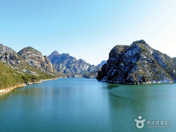
Chungjuho Lake (충주호)
12.2 Km 38114 2024-03-08
Jodong-ri, Dongnyang-myeon, Chungju-si, Chungcheongbuk-do
+82-43-850-5114
Chungjuho Lake is the nation’s largest lake, and was formed after the construction of Chungju Dam. When constructing the dam, an area of approximately 66.48 ㎢ was submerged throughout three regions in Chungju, Danyang and Jecheon. Even though nearly 50,000 people lost their hometown, the lake became a famous regional tourist spot, along with Woraksan National Park, Songgye Valley, Cheongpung Culture Center, Eight Sceneries of Danyang, Gosu Cave, Guinsa Temple, Suanbo Hot Springs, Nodong Cave and other spots.
Tourists can enjoy the scenic area on five ferry docks from Chungjunaru, main ferry dock of Chungju Dam, Cheongpungnaru, Janghoenaru where Gudambong Peak and Oksunbong Peak are located, Danyangnaru in Danyang-eup, and Woraknaru located near the beautiful scenery of Woraksan Mountain. From Chungju Dam to Janghoenaru, it takes approximately 1 hour 30 minutes, making it a long-distance course and offers special sightseeing on board. This course also holds great views of Chungjuho Lake and Yeongbong Peak of Woraksan Mountain, the surrounding scenery of Woraknaru, and two scenic spots of Danyang which are Gudanbong and Oksunbong Peak featuring uniquely-shaped rocks and peaks. This course is the most attractive among Chungjuho ferry excursion routes.
Ageobong Peak (악어봉)
12.4 Km 0 2024-02-22
Sindang-ri, Salmi-myeon, Chungju-si, Chungcheongbuk-do
Ageobong Peak is situated within Woraksan National Park near Chungjuho Lake. It is so named because the mountain's foothills, as seen from the summit overlooking Chungjuho Lake, resemble a group of crocodiles entering the water—'ageo' translates to 'crocodile' in Korean. In 2023, a trail was opened for tourists, offering them the chance to enjoy the breathtaking landscape from an observatory at the peak.
Jongdaengi Trail (충주호 종댕이길)
12.5 Km 13461 2024-02-22
Jongmin-dong, Chungju-si, Chungcheongbuk-do
Simhangsan Mountain, located adjacent to Chungjuho Lake, is affectionately known as Jongdaengi Mountain due to the presence of a shrine. The construction of Chungju Dam in 1985 led to the formation of Chungjuho Lake and the subsequent disappearance of a village. The Jongdaengi Trail, a scenic walking path along Simhangsan Mountain, offers breathtaking views of Chungjuho Lake. Along the trail, visitors can discover an ecological pond and a suspension bridge, enhancing the overall experience.
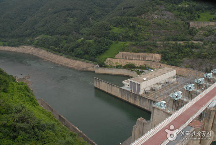
Chungju Dam (충주댐)
12.8 Km 21123 2021-04-29
737, Chungjuhosu-ro, Chungju-si, Chungcheongbuk-do
+82-43-840-1207
Chungju Dam is the nation’s largest multipurpose concrete dam and plays a role in water resources planning and management, prevention of flood damage, and electric power production. The dam area features various facilities like the Water Exhibition Hall, Memorial Tower, a resting area, and a tour boat dock. As for the structure, the dam is 97.5 meters high and 447 meters long. Beneath the main dam, there is a balancing reservoir dam which is 21 meters high and 480.7 meters long.
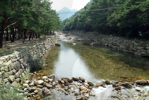
Songgyegyegok Valley (송계계곡)
13.1 Km 93368 2022-07-25
Mireuksonggye-ro, Jecheon-si, Chungcheongbuk-do
+82-43-653-3250
Songgyegyegok Valley lies at the foot of Woraksan Mountain in Jecheon, Chungcheongbuk-do. Crystal-clear water flows between the rocks that are scattered throughout the valley. The valley is a perfect summer getaway as the forest and cool water provide much needed shelter from the heat. In fall, visitors can enjoy fall foliage. There are various attractions in the mountain for visitors to explore.
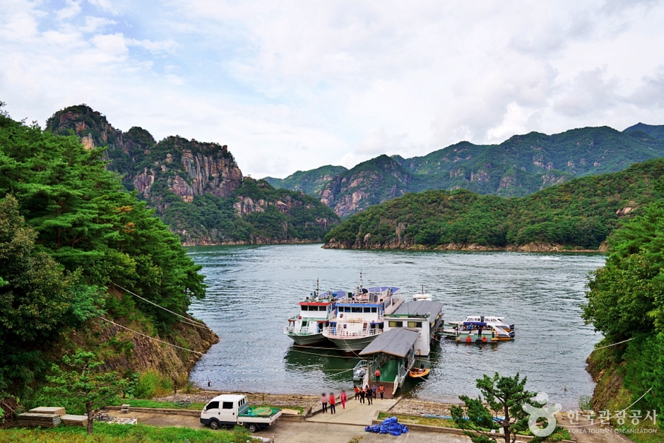
Janghoe Quay (장회나루)
13.1 Km 0 2024-02-27
3811-19 Worak-ro, Danseong-myeon, Danyang-gun, Chungcheongbuk-do
Janghoe Quay is a pavilion where visitors can enjoy the breathtaking scenery of Gudambong Peak and Chungjuho Lake in Danyang. The towering mountains, cliffs, and the shimmering waves of Chungjuho Lake create a beautiful landscape. With the presence of the Chungjuho Excursion Boat Terminal, it is a popular destination for domestic and international travelers, offering the opportunity to take a cruise around Danyang.
 English
 한국어
한국어 日本語
日本語 中文(简体)
 Deutsch
 Français
 Español
 Русский