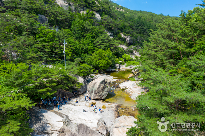
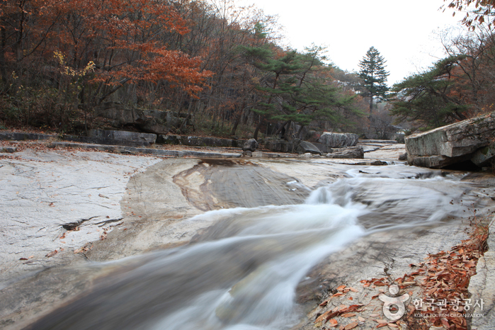
Seonyudonggyegok Valley (선유구곡(선유동계곡))
16.8Km 2021-07-29
179, Seonyudong-gil, Goesan-gun, Chungcheongbuk-do
+82-43-832-4347
Seonyudonggyegok Valley is located in Goesan-gun, Chungcheongbuk-do Province. Including Seonyudongmun, the playground for the mountain gods, a total of nine valleys form the area: Gyeongcheonbyeok, Haksoam, Yeondallo, Waryongpok, Nangadae, Gigugam, Guam, and Eunseonam.
Seonnyudonggyegok Valley is famous for the legend that mountain gods came to savor fresh mountain spring water. A renowned geographical account, Taekriji, published in 1751, stated that Seonyudonggyegok Valley boasted some of the best scenery. One of the most eminent Confucian scholars of the Joseon dynasty, Lee Hwang spent nine months in this beautiful valley. He gave names to all his favorite places, which still remain to this day.

Chungju Tangeumdae Height & Park (충주 탄금대와 탄금대공원)
16.9Km 2021-07-21
105, Tangeumdaean-gil, Chungju-si, Chungcheongbuk-do
+82-43-848-2246
Tangeumdae x_height was originally a mountain named Daemunsan Mountain. The scenery is amazing with rocky cliffs, the nearby Namhangang River, and lush pine forests. The place was named Tangeumdae because it was where Ureuk, the celebrated musician of the Silla dynasty (57 BC-AD 935), used to play the gayageum (traditional stringed instrument).
![Himart - Chungju Yeonsu Branch [Tax Refund Shop] (하이마트 충주연수점)](http://tong.visitkorea.or.kr/cms/resource/50/2882950_image2_1.jpg)
Himart - Chungju Yeonsu Branch [Tax Refund Shop] (하이마트 충주연수점)
17.1Km 2024-04-19
214, Gyemyeong-daero, Chungju-si, Chungcheongbuk-do
-
![Uniqlo - Chungju Branch [Tax Refund Shop] (유니클로 충주)](http://tong.visitkorea.or.kr/cms/resource/40/2882940_image2_1.jpg)
Uniqlo - Chungju Branch [Tax Refund Shop] (유니클로 충주)
17.1Km 2024-04-17
191, Gyemyeong-daero, Chungju-si, Chungcheongbuk-do
-
Ageobong Peak (악어봉)
17.4Km 2024-02-22
Sindang-ri, Salmi-myeon, Chungju-si, Chungcheongbuk-do
Ageobong Peak is situated within Woraksan National Park near Chungjuho Lake. It is so named because the mountain's foothills, as seen from the summit overlooking Chungjuho Lake, resemble a group of crocodiles entering the water—'ageo' translates to 'crocodile' in Korean. In 2023, a trail was opened for tourists, offering them the chance to enjoy the breathtaking landscape from an observatory at the peak.
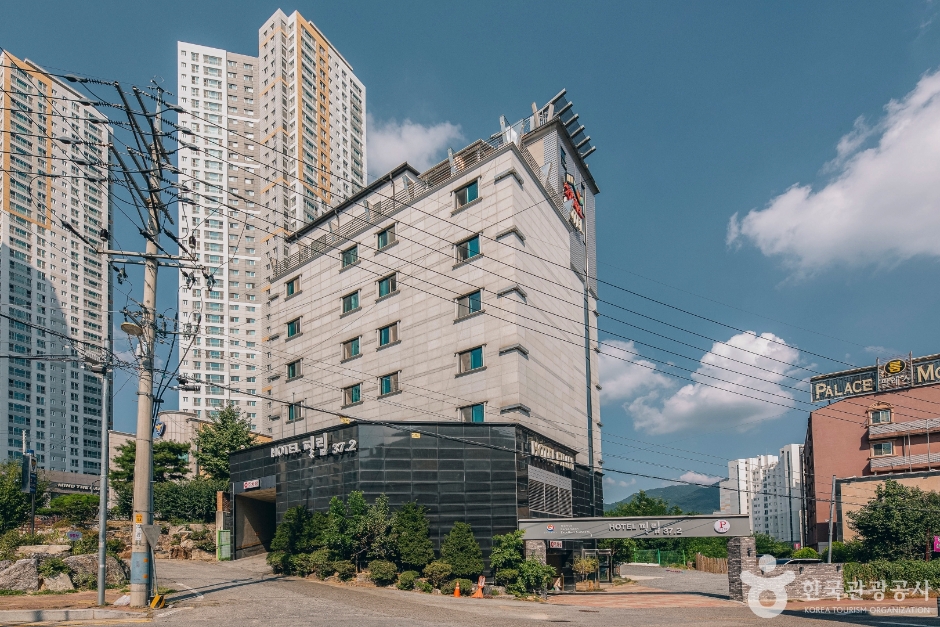
Hotel Film 37.2 (호텔 필림37.2)
17.6Km 2024-12-23
17 , Yeonwon-ro, Chungju-si, Chungcheongbuk-do
+82-43-842-0515
Hotel Film 37.2, located in Chungju, Chungcheongbuk-do, is conveniently located near Chungju City Hall. Rooms are mediculously decorated in three different styles - Korean, European, and Japanese - depending on which floor they are on. Especially, the Korean-style room has a door in the shape of a traditional Korean gate, and the paper ornaments and muntin-style windows give it a warm, old-fashioned feel.
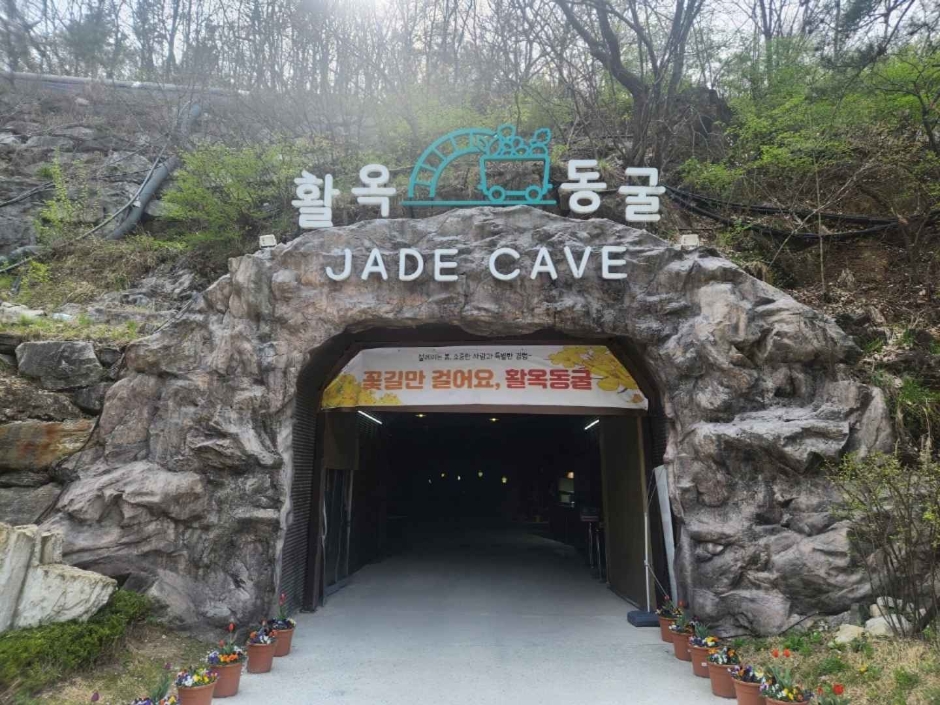
Chungju Hwalok Cave (충주 활옥동굴)
18.1Km 2025-03-16
26 Mokbeoran-gil, Chungju-si, Chungcheongbuk-do
Developed in 1922 during the Japanese Forced Occupation, this is the only talc mine in Korea and is the largest in the East, with a recorded length of 57km, an unofficial length of 87km, and an underground vertical x_height of 711m. A 2.5km-long stretch of the cave has been developed into a tourist site, filled with light sculptures, performance venues, and health therapy zones. LED, neon, and a variety of natural lights create a mysterious atmosphere, and since the temperature stays between 11 and 15 degrees year-round, it's even more popular in summer. There is also a kayaking experience that allows visitors to see inside the cave by kayaking in a lake created by mineral water.
Note that the temperature inside the cave averages between 11 and 15 degrees Celsius, which is warm in the winter but cold in the summer, so you'll want to bring a long-sleeved jacket.
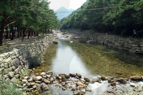
Songgyegyegok Valley (송계계곡)
18.6Km 2022-07-25
Mireuksonggye-ro, Jecheon-si, Chungcheongbuk-do
+82-43-653-3250
Songgyegyegok Valley lies at the foot of Woraksan Mountain in Jecheon, Chungcheongbuk-do. Crystal-clear water flows between the rocks that are scattered throughout the valley. The valley is a perfect summer getaway as the forest and cool water provide much needed shelter from the heat. In fall, visitors can enjoy fall foliage. There are various attractions in the mountain for visitors to explore.
Woraksan National Park (월악산국립공원)
18.8Km 2023-03-24
1647, Mireuksonggye-ro, Jecheon-si, Chungcheongbuk-do
+82-43-653-3250
Woraksan National Park is located along the Baekdudaegan Mountain Range between Sobaeksan and Songnisan Mountains. The rugged mountain is softened by the waterfalls and small pools found within the valleys. The area was designated as a national park on December 31, 1984. The mountain is surrounded by Chungjuho Lake to the north, the Eight Scenic Views of Danyang and Sobaeksan Mountain to the east, and Mungyeongsaejae Pass and Songnisan Mountain to the south. The main peak of Woraksan National Park is Yeongbong Peak, reaching an altitude of 1,097 meters above sea level. The path there is steep, with sections of rock stretching 150 meters in x_height. There is also a 4-kilometer-long path circling the base rock.
Mungyeong Seonyudonggyegok Valley (선유동계곡(문경))
19.0Km 2025-09-10
Wanjang-ri, Mungyeong-si, Gyeongsangbuk-do
+82-54-550-6392
Seonyudonggyegok Valley in Mungyeong is longer and more beautiful than the valley of the same name in Goesan. Daeyasan Mountain (931 meters) runs across both valleys, which are 10 kilometers apart from each other. The valley is relatively untouched as it is not yet well known to the public. At the beginning and the end of the trail are Hakcheonjeong and Chirujeong Pavilions, respectively. Both sides of the valley are lined with thick forests of ancient pine trees. A number of stone carvings can be found in the forest, and the most famous one reads “Seonyugyegok.” It was written by Choi Chi-won, a leading scholar of the Silla kingdom.
 English
 한국어
한국어 日本語
日本語 中文(简体)
 Deutsch
 Français
 Español
 Русский