![Hantangang River [National Geopark] (한탄강(국가지질공원, 고석정))](http://tong.visitkorea.or.kr/cms/resource/52/2675252_image2_1.jpg)
Hantangang River [National Geopark] (한탄강(국가지질공원, 고석정))
16.7 Km 3 2022-06-02
1825 , Taebong-ro, Cheorwon-gun, Gangwon-do
+82-33-450-4810
Goseok Rock, located in the area of Hantangang River, is a granite rock that reach 15 meters in x_height. The area is often called Goseokjeong, named after the nearby Goseokjeong Pavilion. The area is an important geology and topography learning site where it is visible to see the topography before the formation of the basalt lava field and the fact that the basalt lava flowed over the bedrock to form the lava field. Goseok is a bedrock that existed before the area of Cheorwon was covered with lava, and is a granite formed underground about 110 million years ago (mid Cretaceous period). It is covered in basalt lava by volcanic activity that occurred between about 540,000 and 120,000 years ago, and then eroded by the Hantangang River to form a new waterway.
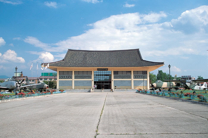
Cheorwon Facilities Management Office (Formerly, Iron Triangle Battlefield (철원 시설물관리사업소 (구 철의삼각전적관))
16.7 Km 28634 2020-03-27
1825, Taebong-ro, Cheorwon-gun, Gangwon-do
+82-33-450-5559
Located in Goseokjeong National Tourism Site, Cheorwon Facilities Management Office is the main tourism center hosting the Cheorwon tour. Starting from Security Tourist Site Development Plan by Cheorwon-gun county in 1976 , the Ministry of Transportation designated Goseokjeong as Goseokjeong National Tourist Area in 1977. The military and Cheorwon-gun county carried out security and battlefield excavation and preservation projects, and established a security educational site featuring the national largest scale in 1985.
Presently, the Iron Triangle Battlefield, located in Goseokjeong National Tourist Area, is used as a security educational site. Unification Hall found within houses various exhibitions, giving information to compare with current and past lifestyles and military devices including varied aircrafts displayed in the outdoor exhibition area. In the educational hall, a promotional video for Cheorwon is screened. Likewise, the exhibition hall covers various materials that allow one to think about unification between North Korea and South Korea.
Goseokjeong National Tourist Area (고석정국민관광지)
16.7 Km 18803 2023-03-07
1825, Taebong-ro, Cheorwon-gun, Gangwon-do
+82-33-450-5558
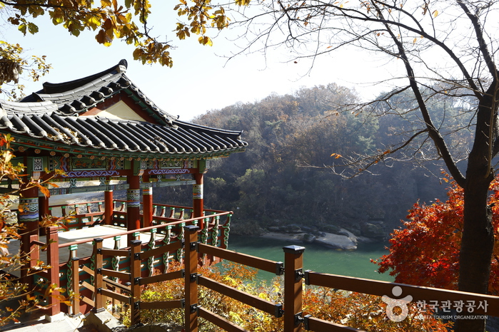
Goseokjeong Pavilion is the most scenic spot among the eight scenic views of Cheorwon. The crystal clear waters of the Hantangang River wind around Goseokbawi Rock, a peculiarly shaped rock about 10 meters tall that stands dominantly in the middle of the river. Goseokjeong Pavilion is a two-story tower-style pavilion that has an area of about 33 square meters, built halfway up the Hantangang River during the reign of King Jinpyeong (r. AD 579-632) of the Silla Kingdom. Today, Goseokjeong refers to the entire area around Goseokjeong Pavilion and the valley surrounding Goseok Rock. Designated as a Monument of Gangwon-do, the pavilion is known to have been one of the most favored places by King Jinpyeong of the Silla Kingdom, and King Chungsuk of the Goryeo dynasty. The area became all the more famous as the arena of Im Kkeok-jeong (?-1562), who was a legendary leader of a peasant rebellion in the early Joseon dynasty.
The pavilion was destroyed during the Korean War and restored in 1971 by community leaders in Cheorwon. Unfortunately, it was damaged once again by flood in 1996 and reconstructed the year after. There is a natural stone chamber inside Goseokbawi Rock that Im Kkeok-jeong used as a hiding place. On the opposite side, there are remains of a stone castle. Jiktang Waterfall is located about 2 kilometers up from this site, while Sundam Valley is situated about 2 kilometers in downstream. Goseokjeong is a year-round tourist attraction with an extensive grass square and recreational facilities. It is also the starting point for DMZ tours as the Iron Triangle Battlefield Conservation Office is located here and in winter, visitors can enjoy migratory bird tours.
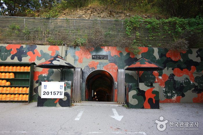
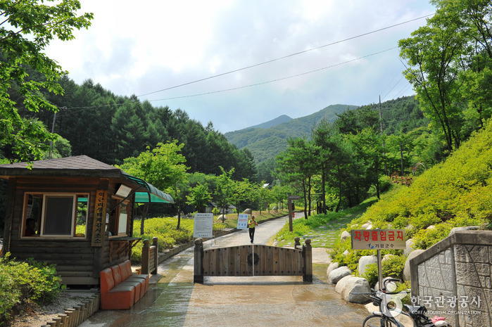
The 2nd Tunnel (제2땅굴(철원))
16.7 Km 30597 2024-03-20
Yangji-ri, Dongsong-eup, Cheorwon-gun, Gangwon-do
+82-33-450-5559
The 2nd Tunnel, one of several excavated by North Korea for the purpose of infiltrating South Korea, was discovered in 1975. Spanning a total length of 3.5 kilometers, only 500 meters of the tunnel is accessible to civilians. To visit this site, visitors are required to book as part of the DMZ Peace Tours. Additionally, personal identification, such as a passport or Alien Registration Card (ARC), is necessary for access.
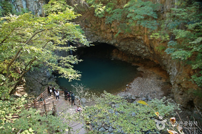
Bidulginangpokpo Falls-Hantangang River Geopark (비둘기낭폭포-한탄강 국가지질공원)
16.8 Km 303 2019-09-03
Daehoesan-ri, Pocheon-si, Gyeonggi-do
+82-31-538-2312
Bidulginangpokpo Falls, Natural Monument No. 537, is located within a small valley. The waterfall is surrounded by grand columnar joints. The landscape appears quite mysterious and serene, earning it a spot as a poplar filming site for historical dramas. The falls gets it's name ("Pigeon Falls" in Korean) from the story of many wild pigeons nesting in the caves around the waterfall. Other say the name comes from the area's shape. During heavy rainfall, the road to the waterfall is closed, so checking the weather before visiting is recommended.
Myeongjisan County Park (명지산 군립공원)
17.2 Km 46581 2021-04-16
Baekdun-ro 650beon-gil, Gapyeong-gun, Gyeonggi-do
+82-31-582-0103
Standing at 1,267 meters above sea level, Myeongjisan Mountain is the second highest mountain in Gyeonggi-do after Hwaaksan Mountain. It is a popular destination all year round, as it offers plenty of resting areas with splendid views of the surrounding nature.
In addition, Myeongjigyegok Valley, spanning 30 kilometers, is a great outdoor picnic spot, while the trail from Sangpan-ri to Ikgeun-ri is the most preferred hiking trail on the mountain.
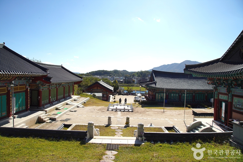
Simwonsa Temple (심원사(철원))
17.3 Km 28648 2024-03-20
58 Sangno 1-gil, Dongsong-eup, Cheorwon-gun, Gangwon-do
This thousand-year-old temple is revered as a sanctuary dedicated to the living Ksitigarbha Bodhisattva. The temple complex comprises various buildings, including Daeungjeon Hall, Myeongbujeon Hall, and Samseonggak Hall. Myeongbujeon Hall is particularly notable as it enshrines the statue of Ksitigarbha, which has been designated a Treasure of Korea. It is believed that if one prays earnestly, a single wish will be granted. This belief continues to draw Buddhists on pilgrimages, eager to experience the spiritual wonder of this revered sculpture.

Jipdarigol Recreational Forest (집다리골자연휴양림)
18.3 Km 17198 2021-04-20
130, Hwaakjiam 1-gil, Sabuk-myeon, Chuncheon-si, Gangwon-do
+82-33-248-6716
This recreational forest, famous for its clear water and broad-leaved virgin forest, is located at the foot of the Hwaaksan Mountain (1,468 m). The name of Jipdarigol has an amusing legend behind it: a young woman and a man, living on the different sides of a large valley, fell in love with each other and made a straw bridge (“jipdari”) to meet each other. Jipdarigol Recreational Forest of today is a popular destination for summer and fall, thanks to its wonderful valley and beautiful forest. The forest includes accommodations and an open-air deck for day trippers, installed along the valley with a x_width of 8 m2 and 15 m2. It can be used until 19:00, and tents and simple cooking are allowed. However, visitors are prohibited from using charcoal and wood fire, and electric equipment. Other facilities include the walking trail, hiking trails, and suspension bridge.
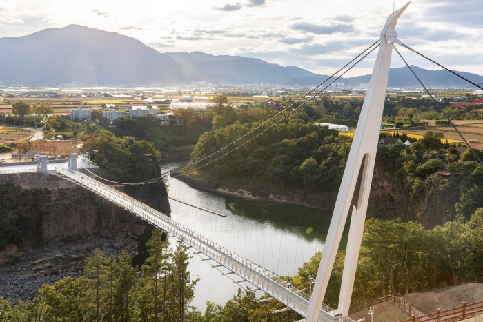
Cheorwon Hantangang Milky Way Bridge (철원 한탄강 은하수교)
18.5 Km 0 2023-03-07
725-12, Jangheung-ri, Cheorwon-gun, Gangwon-do
+82-33-450-5365
The area of Hantangang River is a UNESCO Global Geopark. The Milky Way Bridge was built to follow a natural path and allows visitors to journey comfortably. The name of the bridge takes from the famous Hantangang River and region of Cheorwon and adds eunhasu, or Milky Way, the path made of stars.
Yeoninsan Provincial Park (연인산도립공원)
19.0 Km 16874 2018-10-25
Buk-myeon, Ha-myeon, Gapyeong-eup, Gapyeong-gun, Gyeonggi-do
+82-31-8008-8140
The source of Yongchu Falls, Mount Yeoninsan (연인산) stands at 1,068 meters above sea level and features soft terrain and beautiful scenery. Local folklore has it that those coming to the mountain wishing for true love will have their dreams come true.
The soil of Mount Yeoninsan is fertile, offering a great natural environment for a variety of flowers and trees. Numerous types of wild flowers thrive from early spring to late autumn. The trail connecting Mount Yeoninsan with mounts Myeongjisan, Cheonggyesan, and Gwimokbong remains relatively unspoiled by human influence: cooking and camping in the area is strictly forbidden. All the mountains in the trail are over 1,000 meters high. A defining feature of Mount Yeoninsan is the royal azaleas that bloom in late May. The County of Gapyeong celebrates the royal azalea by hosting the Mount Yeoninsan (Natural Ecology) Festival in May of each year.
Also ideal for hiking, Mount Yeoninsan offers a number of trails: one starts from Buk-myeon in Baekdun-ri, one from Mail-ri, and one from Yongchu Valley. With a minimum of climbing, hikers can take in a variety of scenic views, ranging from the bloom of the royal azaleas in the spring to the beauty of the changing leaves in the fall.
 English
 한국어
한국어 日本語
日本語 中文(简体)
 Deutsch
 Français
 Español
 Русский