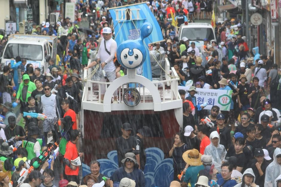
Jeongnamjin Jangheung Water Festival (정남진 장흥 물축제)
16.5Km 2025-07-11
805 Geosan-ri, Jangheung-eup, Jangheung-gn, Jeollanam-do
+82-61-860-5771
The Jeongnamjin Jangheung Water Festival is held in the cleanest locations, such as the Tamjingang River, Jangheung Dam, and Deungnyangman Beach. The summer festival runs a variety of programs and games under the familiar theme of “water” for those who want to get out of the heat.

Jeamsan Recreational Forest (제암산자연휴양림)
16.8Km 2021-07-02
330, Daesan-gil, Boseong-gun, Jeollanam-do
+82-61-852-4434
Jeamsan Mountain is beautiful throughout the year with royal azaleas in spring, cool water in summer, silver grass in fall, and a snow-covered mountain in winter. The mountain attracts over 100,000 visitors during vacation periods with Yongchugyegok Valley nearby. Just over the mountain is the ocean with Yulpo Beach where visitors can enjoy after relaxing at Jeamsan Recreational Forest.
Yulpo Beach (Solbat Beach) (율포해수욕장(솔밭해변))
17.0Km 2021-07-15
24, Uam-gil, Boseong-gun, Jeollanam-do
+82-61-850-5211
Yulpo Beach is a scenic beach with a 60-meter-wide, 1.2-kilometer-stretch of silver sand between the sea and a forest of 100-year-old pine trees. Despite its location in a small fishing village, the region’s famous green tea and beautiful beaches have resulted in attracting many tourists to Yulpo Beach. The area has become a family summer resort, fully equipped with accommodation and leisure facilities.
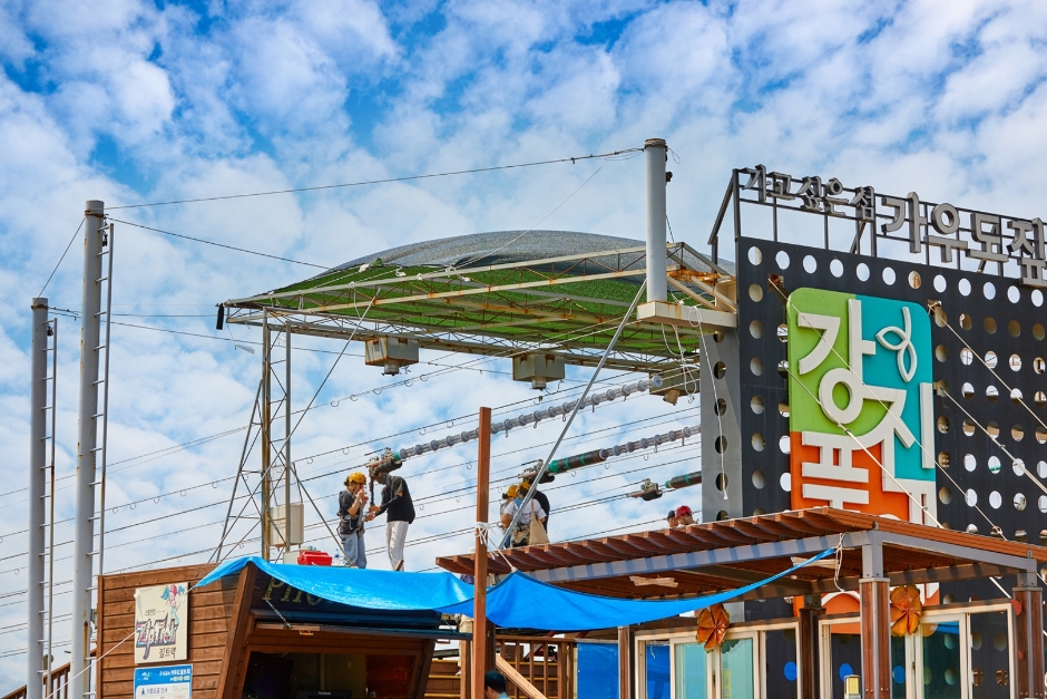
Gangjin Ziptrek (강진 짚트랙)
17.0Km 2024-01-11
49-9 Gaudo-gil, Doam-myeon, Gangjin-gun, Jeollanam-do
This exciting activity can be enjoyed at the 25-meter high celadon tower located in the center of Gaudo Island. Gaudo Ziptrek is approximately 1 kilometer long and boasts the longest one in Korea as a maritime experience facility. After wearing safety equipment on the tower's first floor, visitors can ride the Ziptrek at the top of the sixth floor. The ziptrek offers an exhilarating downhill slide that feels like flying in the sky with magnificent scenery that unfolds down below. The slide ends at the entrance to the suspension bridge.
Maryang Port (마량미향(마량항))
17.6Km 2024-02-16
150 Mihang-ro, Maryang-myeon, Gangjin-gun, Jeollanam-do
Maryang Port, situated along the pristine waters linking Wando Island, the Dadohae islands, and Jeju, is a notable destination. From April to October, it becomes the venue for the Maryang Nolto Fish Market every Saturday. This market is celebrated for its lavish food selections and the spectacle of raw fish being expertly sliced before visitors. Adjacent to the port, an observatory provides sweeping views of the stunning Gangjin seas. Additionally, the nearby Kkamakseom Island, recognized as a Natural Monument, is visible from this vantage point, adding to the area's allure.
Gaudo Island (가우도)
18.0Km 2025-01-17
473, Wolgot-ro, Gangjin-gun, Jeollanam-do
+82-61-430-3114
Gaudo Island is the only populated island of the eight islands in Gangjinman Bay. The name comes from its appearance in relation to Boeunsan Mountain in Ganjin-eup, which looks like a cow’s head. The whole island resembles a cow’s meonge (curved stick around cow’s neck used to drag farming tool) so the island became to be called Gaudo Island (Ga: Meonge in Chinese characters).
From Gaudo Island, Gangjinman Bay and the uninhabited islands can be seen in all directions. The coastal scenery is stunning and varied natural tourism resources grow here such as the silver magnolia, cypress colony, and Japanese black pines. Visitors can walk to the island from the mainland via a suspension bridge. When arriving to the island, a 2.5-kilometer long ecological exploring road along the mountain and coast is available. Also, fishing park which has various kinds of fishes is located in the spot where visitors can overlook at beautiful scenery of Gangjinman Bay. At the top of the island, visitors can enjoy a zip track which is an eco-friendly leisure facility, starting from the 25-meter Cheongja Tower.

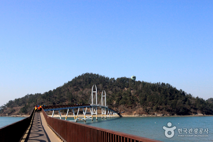
Gaudo Suspension Bridge (가우도 출렁다리)
18.0Km 2024-01-11
San 7-1 Singi-ri, Doam-myeon, Gangjin-gun, Jeollanam-do
Gaudo Island, the only inhabited island among Gangjin's eight islands, is connected to the mainland by a suspension bridge. The suspension bridges installed on both sides of the island have emerged as Gangjin's famous destination, attracting hundreds of thousands of visitors every year. While crossing the dizzying suspension bridge, one can see the wonderful seascape that changes in brightness depending on the waves. The footbridges, Jeodu Suspension Bridge (438 m) or Dasan Bridge (716 m), can be used to entrance Gaudo Island, and there is also a clean trail along the coastline. It takes about one to one and a half hours to walk across both bridges, making it a great place to enjoy a walk.
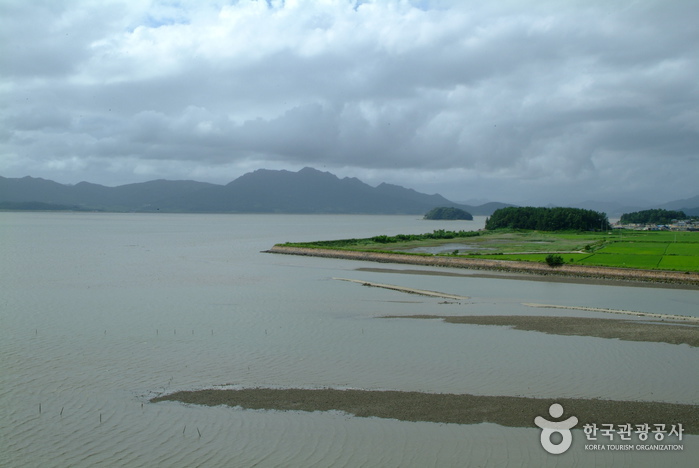
Gangjinman Bay (강진만)
18.8Km 2020-03-27
Beoljeong-ri, Gangjin-gun, Jeollanam-do
+82-61-430-3114
Gangjin has many scenic landscapes with Wolchulsan Mountain to the north and the sea of Gugangpo dotted with numerous islets and wetlands to the south. It is also home to beautiful mountains, rivers, and plains that add to its scenic beauty and natural features. The Baengnyeonsa Temple and Dasan Chodang to the west of Gangjinman Bay, and the reeds along the coastline are a beautiful sight to behold. Also, the National Highway No. 23 that runs along the eastern border of the Gangjinman Bay, past the town of Gangjin-eup to Maryang, is famous for its many spectacular sights. Above all, it is highly recommended to hike up the Cheonilgak Pavilion in front of the Dasan Chodong Dongam (east hermitage) for a panoramic view of Gugangpo’s coastal waters. The hiking trail that traverses Mandeoksan Mountain leads to Baengnyeonsa, which is a temple with breathtaking ocean view.
 English
 한국어
한국어 日本語
日本語 中文(简体)
 Deutsch
 Français
 Español
 Русский