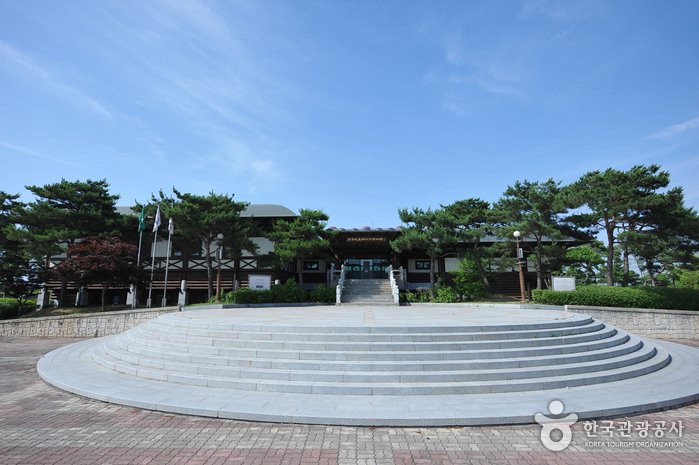
Byeokgolje Museum of Agricultural Culture (벽골제 농경문화 박물관)
16.9Km 2024-04-06
442, Byeokgolje-ro, Gimje-si, Jeonbuk-do
+82-63-540-4989
The largest irrigation facility in Korea, Byeokgolje Reservoir (Historic Site) is considered the birthplace of Korea’s rice-farming culture. All that remains of the reservoir today are a three-kilometer long embankment that spans from Sinyong-ri to Wolseung-ri in Buryang-myeon, Gimje-si and a monument that was erected in 1415. The Byeokgolje Museum of Agricultural Culture exhibits around 250 artifacts related to rice farming; located within the same complex is an experience center where visitors can discover many properties of irrigation facilities first-hand.
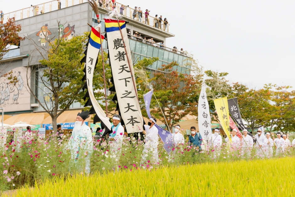
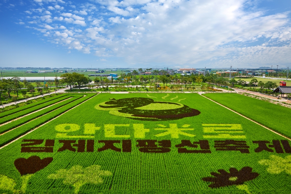
Gimje Horizon Festival (김제지평선축제)
16.9Km 2025-07-09
442 Byeokgolje-ro, Buryang-myeon, Gimje-si, Jeonbuk-do
+82-63-540-3037
In Korea, finding an unobstructed horizon is a rarity, making Gimje’s expansive horizon a unique and stunning sight. Held in the autumn when the fields are tinged with gold, the Gimje Horizon Festival celebrates this unique landscape. The festival aims to promote Gimje’s famous rice and preserve traditional agricultural culture based on the theme of, “where the land meets the sky.” The torch parade at night is the highlight of the festival. The spectacular performance in front of the huge twin dragon sculptures standing at the center of the Byeokgolje Reservoir (Historic Site No. 111) perfectly captures the festival’s vibrant and passionate atmosphere. Throughout the festival venue, there are farming activities, such as harvesting rice and threshing, as well as rural experiences of the past, such as catching grasshoppers and riding an ox cart.
◎ Byeokgolje Reservoir
Built during the Baekje period, the manmade reservoir shows the wisdom of Korea’s ancestors and the old agricultural system. On the embankment more than 3 kilometers long, five floodgates were installed to discharge water into the rice fields.
Byeokgolje Reservoir Site (김제 벽골제)
16.9Km 2024-04-07
442 Byeokgolje-ro, Buryang-myeon, Gimje-si, Jeonbuk-do
+82-63-540-4094
Byeokgolje Reservoir Site is home to the embankment and stele recording reconstruction for Korea’s first ever reservoir. Records show it was rebuilt in the 6th year of King Wonseong of Silla (790), the 21st year of King Hyeonjong and King Injong of Goryeo (1143), and then again in the 15th year of King Taejong of Joseon (1415). It was lost due to heavy rain in 1420 (the 2nd year of King Sejong's reign).
Currently, only about 3 kilometers of straight embankment remains on the site. In 1925, the Dongjin Land Improvement Association remodeled this embankment and used it as a channel for providing water for farming, thus losing a lot of its original appearance. A monument was erected on the north side of the embankment to commemorate the rebuilding of Byeokgolje Reservoir during the Joseon Dynasty. However, it is difficult to read the writing because it is worn out.
In 1975, two sites with water gates that controlled the water in the reservoir were excavated, and the results showed that the construction used large-scale, high-level engineering technology. Byeokgolje Reservoir is not only significant in that it was Korea's first reservoir but also proves that the country’s civil engineering technology was developed enough to build such a reservoir at the time, revealing a groundbreaking fact in the history of science and technology in Korea.
Nearby tourist attractions can be visited together: Byeokgolje Agricultural Museum, where you can get a glimpse of the old agricultural culture, Theme and Experience Space for Agriculture, and Byeokcheon Art Gallery, which displays the works of Na Sang-mok, an Oriental Painting artist in Korea.
* Pets are allowed; however, a leash is required.

Buan Sports Park (부안스포츠파크)
17.7Km 2024-04-07
31, Cheyukgongwon-gil, Buan-gun, Jeonbuk-do
+82-63-580-3904
Buan Sports Park spans over an area of 82,644 square meters. The park has a natural grass soccer field equipped with 6,700 seats, track and field made with natural rubbers, a torch holder, tennis courts, baseball field, basketball court, footsal field, an in-line skating track, an experience hall for children, a playground, and more, as well as lighting facilities for nighttime events. Other facilities include water fountain, grass performance hall, various types of trees and flowers, benches and rest areas. With accommodations nearby, the park is used as a training facility for teams from elementary school students to even professional athletes.
Buan Guam-ri Dolmens (부안 구암리 지석묘군)
17.7Km 2024-04-07
Seoksang-ri, Buan-gun, Jeonbuk-do
+82-63-580-4711
Buan Guam-ri Dolmens, designated as Historical Site No. 103, is comprised of southern-style dolmens. Dolmen refers to a particular structure of a tomb created during the Bronze Age. Dolmen is largely classified into two groups – Southern-type that has small footstones supporting large top stone; and Northern-type which is shaped like a desk. In Guam-ri, there were originally 13 dolmens, but only 10 remain. Most of the dolmens have 8 small footstones propping up one large top stone, compared to the dolmens in other regions which normally have 4 footstones.
Deoksugung Haemul Kalguksu (덕수궁해물칼국수)
17.7Km 2024-02-28
5, Jangsan-ro 855beon-gil, Maseo-myeon, Seocheon-gun, Chungcheongnam-do
041-956-7066
Located near the Geumgang Estuary Embankment, Deoksugung Haemul Kalguksu serves haemul kalguksku (noodle soup with seafood) full of clams and vegetables. Kalguksu (noodle soup) is made by rolling out a thin flour dough, slicing it into thin strips, and then boiling them in a soup. There’s a variety of kalguksu (noodle soup) dishes on offer, along with wangmandu (jumbo mandu). The broth is clean, thanks to shrimp and fresh vegetables. Don’t miss yeolmu kimchi (young summer radish kimchi), which is served as a side dish in the restaurant and goes perfectly with kalguksu (noodle soup).
Yubudo Island (유부도)
18.0Km 2024-02-21
Yubudo-gil, Janghang-eup, Seocheon-gun, Chungcheongnam-do
Yubudo Island is a small island in front of Seocheon's coastline, accessible by ferry from Janghang Port in about 30 minutes. The island boasts extensive tidal flats and saltern developed with embankment. It is a place where saltwater and freshwater mix, making it abundant in fish like grey mullet and shrimp. Yubudo Island is also known as a resting spot for over 100 species of migratory birds.
Bieung Mapaji Trail (비응 마파지길)
18.3Km 2024-04-06
1331 Oehang-ro, Gunsan-si, Jeonbuk-do
Bieung Mapaji Trail is a deck walkway along the coast of Biungdo Island. "Mapaji" means a place where the maparam (south wind) blows in Korean, and visitors can enjoy a refreshing walk while feeling the cool breeze from the sea. While strolling along the coastal scenery, visitors come across observation decks. From these decks, they can enjoy panoramic views of Bieung Port and the expansive scenery of the Seohae Sea.
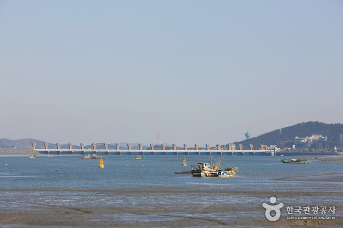
Gunsan Geumgang Estuary Bank (금강하구둑(군산))
18.3Km 2024-04-07
120, Cheolsae-ro, Gunsan-si, Jeonbuk-do
+82-63-454-3353
Geumgang Estuary Bank was completed in 1990 as part of an agricultural development project for 6 cities and counties in Chungcheongnam-do and Jeollabuk-do. The Korea Agricultural and Rural Infrastructure Corporation invested approximately 100 billion won for the project and the construction lasted for 8 years. The estuary bank can hold up to 130 million tons of water. The 1,840-meter long bank serves a bridge that connects Chungcheongnam-do to Jeollabuk-do.
Aside from being the source of water for agricultural and industrial use in Jeollabuk-do and Chungcheongnam-do, the bank also provides flood control for the area around Geumgang River. It helps keep Gunsanhang Port operational by preventing soil
and sand from accumulating at the mouth of the river. It also prevents the backwash of seawater from causing damage to farmlands. Geumgang Estuary Bank has an important role as a tourist destination by connecting Gunsan and Janghang.
Bieung Port (비응항)
18.6Km 2024-04-07
74-11 , Bieungnam-ro, Gunsan-si, Jeonbuk-do
+82-63-454-4000
Bieung Port is the starting point of Saemangeum Embankment which is at the entrance of the Saemangeum tourist area. Bieung Port was once closed due to the excess of soil sedimentation after the construction of Geumgang Estuary seawall. In addition, when the shores were closed off with the Saemangeum Embankment reconstruction project, a new port was in need and thus Bieung Port was repaired and reopened along with two other ports. Bieung Port in particular was constructed as a multi-functioning fisheries port so that it may be incorporated with the nearby attractions in the tourism business.
 English
 한국어
한국어 日本語
日本語 中文(简体)
 Deutsch
 Français
 Español
 Русский