![Daehyun Zooc - Lotte Goyang Terminal Branch [Tax Refund Shop] (대현 주크 롯데고양터미널)](http://tong.visitkorea.or.kr/cms/resource/06/2889706_image2_1.jpg)
Daehyun Zooc - Lotte Goyang Terminal Branch [Tax Refund Shop] (대현 주크 롯데고양터미널)
14.2Km 2024-04-19
1036, Jungang-ro, Ilsandong-gu, Goyang-si, Gyeonggi-do
-
![Lotte Outlets - Goyang Terminal Branch [Tax Refund Shop] (롯데아울렛 고양터미널점)](http://tong.visitkorea.or.kr/cms/resource/60/2890560_image2_1.jpg)
Lotte Outlets - Goyang Terminal Branch [Tax Refund Shop] (롯데아울렛 고양터미널점)
14.2Km 2024-04-22
1036, Jungang-ro, Ilsandong-gu, Goyang-si, Gyeonggi-do
-
![E-Mart - Pungsan Branch [Tax Refund Shop] (이마트 풍산)](http://tong.visitkorea.or.kr/cms/resource/01/2888401_image2_1.jpg)
E-Mart - Pungsan Branch [Tax Refund Shop] (이마트 풍산)
14.3Km 2024-04-22
237, Mugunghwa-ro, Ilsandong-gu, Goyang-si, Gyeonggi-do
-
![CheongKwanJang - Unjeong Branch [Tax Refund Shop] (정관장 운정점)](http://tong.visitkorea.or.kr/cms/resource/94/3314194_image2_1.jpg)
CheongKwanJang - Unjeong Branch [Tax Refund Shop] (정관장 운정점)
14.3Km 2024-06-27
610, Mirae-ro, Paju-si, Gyeonggi-do
-

Olive Young - Paju Garam Branch [Tax Refund Shop] (올리브영 파주가람점)
14.4Km 2024-06-27
2, Garam-ro, Paju-si, Gyeonggi-do
-
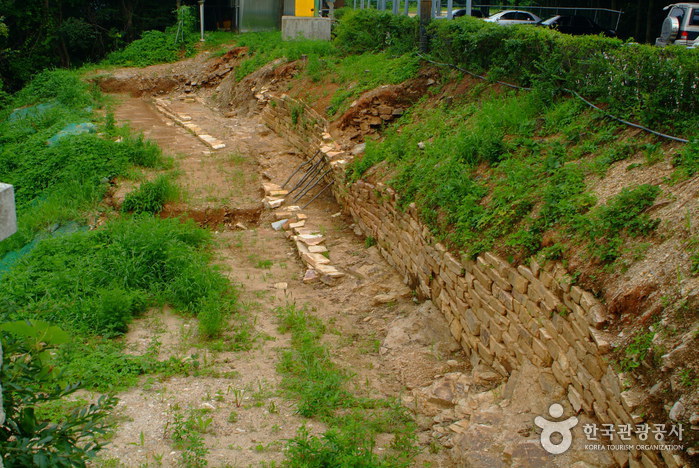
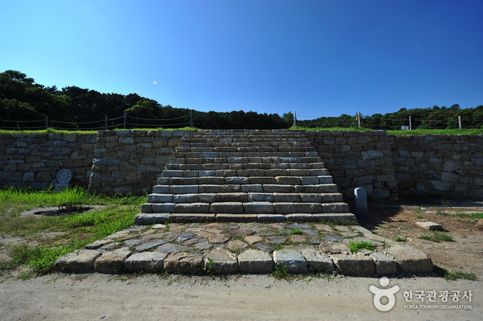
Odusanseong Fortress (파주 오두산성)
14.4Km 2024-12-03
Seongdong-ri, Paju-si, Gyeonggi-do
Odusanseong Fortress is built around the strategic summit of Odusasn Mountain. The walls stretch across roughly 620 meters and were built during the Baekje dynasty. The fortress is built on the intersection of the Imjingang River and the Hangang River on the summit of Odusan Mountain (119 meters). The mountain’s slope is steep and stones used in the construction of the fortress walls are scattered here and there at the summit. These scattered stones are evidence that the fortress underwent repairs several times during the Samguk (Three Kingdoms) era and the Joseon dynasty, as these stones were evidently quarried and used to mend the fortress walls. Excavations have discovered a great deal of earthenware, white porcelain, tile, and iron arrowheads. Topographically, the fortress sits on a prime strategic junction and the Unification Observatory has been situated there as well. The fortress stands as an important object of study concerning fortifications and structures from the Baekje dynasty. It has been recorded on the stele of King Gwanggaeto, Samguksagi (History of the Three Kingdoms), in the Naekjebongi (Baekje Annals) and on Daedongyeojido (Map of Korea) that the fortress was the Gwanmi Fortress of Baekje, attracting many scholars and researchers interested in this period.
![Muji - BELLA CITTA Branch [Tax Refund Shop] (MUJI 벨라시타)](http://tong.visitkorea.or.kr/cms/resource/94/2889494_image2_1.jpg)
Muji - BELLA CITTA Branch [Tax Refund Shop] (MUJI 벨라시타)
14.5Km 2024-04-22
1-2F (Ilsan Bella Citta, Baekseok-dong), 33, Gangsong-ro, Ilsandong-gu, Goyang-si, Gyeonggi-do
-
Olive Young - Ilsan Bella Citta Branch [Tax Refund Shop] (올리브영 일산벨라시타점)
14.5Km 2024-06-26
33, Gangsong-ro, Ilsandong-gu, Goyang-si, Gyeonggi-do
-
Ganghwa Seonwonsa Temple Site (강화 선원사지)
14.6Km 2022-09-19
222, Seonwonsaji-ro, Ganghwa-gun, Incheon
+82-32-933-8234
Ganghwa Seonwonsa Temple Site was first discovered in 1976 during a surface examination around Ganghwado Island undertaken by the Ganghwado Island Academic Research Team of Dongguk University. The site was designated as Historic Site No. 259 in 1977. Seonwonsa Temple was built by General Choi Wu in 1245 (the 32nd year of King Gojong’s reign during the Goryeo dynasty), which was right after the transfer of the capital to Ganghwado during resistance against the Mongolian invasion.
The temple was meant to be a spiritual mainstay in fighting against Mongolia. It used to be one of the two largest temples in Korea along with Songgwangsa Temple. However, the temple was completely destroyed during the early Joseon era, leaving only the site itself. The famous wood blocks of Palman Daejanggyeong (the Tripitaka Koreana), currently housed in Haeinsa Temple at Hapcheon, are said to have been originally stored in Seonwonsa Temple. It is believed that the carved wood blocks were taken from Seonwonsa to Heungcheonsa Temple during the Joseon era and again moved to Haeinsa Temple during the reign of Sejo.
Located on a mountain slope, the presumed location of the building site extends 250 meters from south to north and 170 meters from east to west.
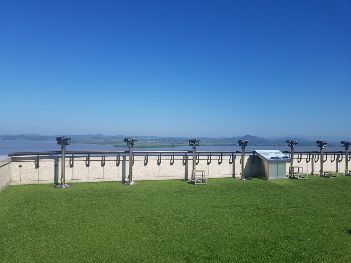
Odusan Unification Observatory (오두산 통일전망대)
14.7Km 2024-12-03
369 Pilseung-ro, Paju-si, Gyeonggi-do
+82-31-956-9600
Located in Tanhyeon-myeon, Paju-si, Odusan Unification Observatory was established to console the feelings of dispersed families and provide an educational site for the unification education through 5F to B1 in 1992.
The observatory is situated in the northernmost ceasefire line of the western front where the Hangang River and Imjingang River meet. It offers a wide view of Songaksan Mountain in Gaeseong to the north and 63 Building in Seoul to the south. Also, it is a valuable unification security tourist attraction related to Imjingak, the 3rd Tunnel, and Panmunjeom (Joint Security Area) stretching along Jayu-ro Road in the northeast.
Since its opening, almost 1,900,000 people have visited the observatory to feel the reality of the division, making this area the best national unification education site.
 English
 한국어
한국어 日本語
日本語 中文(简体)
 Deutsch
 Français
 Español
 Русский