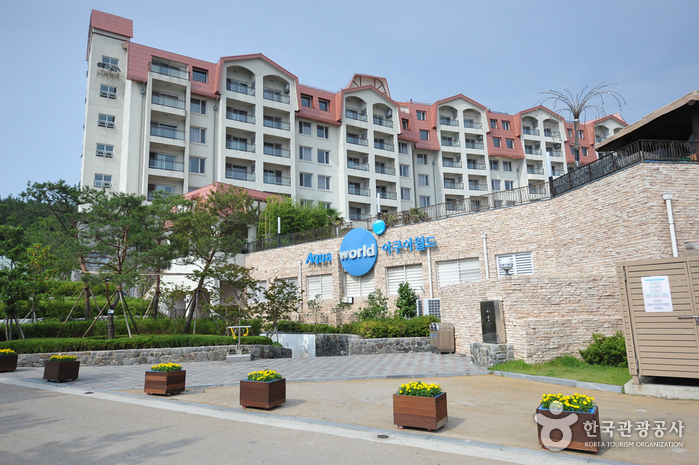
Sono Belle Byeonsan Ocean Play (소노벨 변산 오션플레이)
14.4Km 2024-04-07
51, Byeonsanhaebyeon-ro, Buan-gun, Jeonbuk-do
+82-1588-4888
Sono Belle Byeonsan Ocean Play is located next to Gyeokpo Beach on Byeonsan Peninsula. This luxurious resort is patterned after Normandy Beach and its European-style architecture. With an ocean view throughout the facility, the water park provides guests with various entertainments including an indoor pool, outdoor wave pool, waterslides, baths, sauna and more.
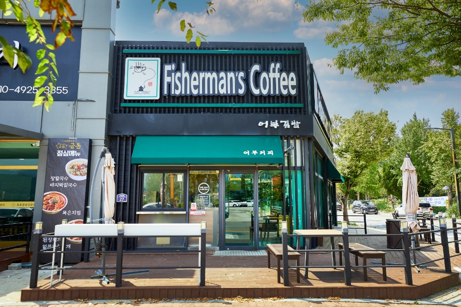
Fisherman’s Coffee (어부김밥커피)
14.4Km 2024-04-07
27, Byeonsanhaebyeon-ro, Buan-gun, Jeonbuk-do
Located across from Gyeokpohaebyeon Beach, this gimbap store also offers coffee and bottled beverages. Its signature menu is gimbap, particularly kkosiraegi (sea string) gimbap. One can also enjoy squid and shrimp gimbap, all perfect menus for seafood lovers. The gimbap here is recommended because these are healthy dishes made with Buan’s specialty. The store also offers beverages and desserts with coffee, so it is a perfect place to drop by and get some food and drinks for a picnic at Gyeokpohaebyeon Beach.
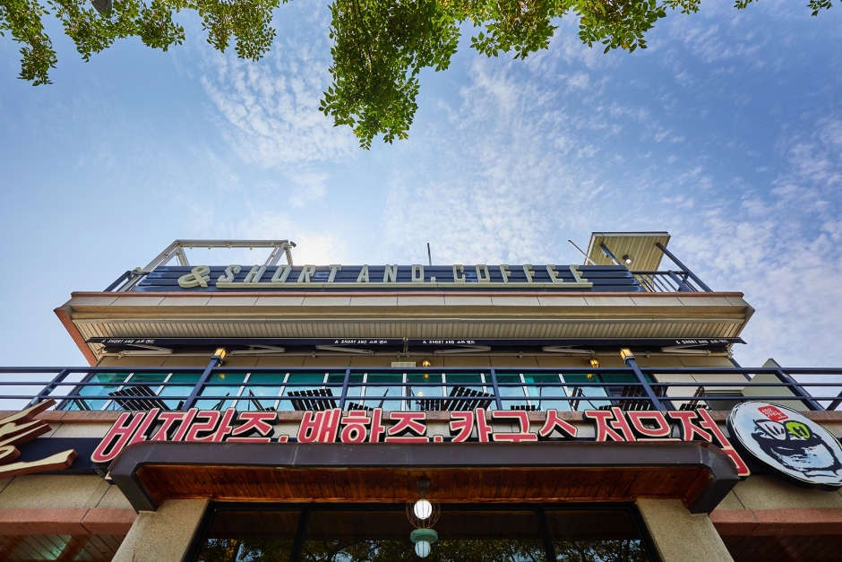
Short And (쇼트앤드)
14.4Km 2024-04-07
13, Byeonsanhaebyeon-ro, Buan-gun, Jeonbuk-do
The café is located on the second floor, so it is a great place to enjoy the view of Gyeokpohaebyeon Beach and the mountains beyond on clear days. The interior tends toward modern and minimalist sensibilities, allowing visitors to focus on the view, while the studio space allows visitors to take pictures with the items on display. The most notable feature of this café is its selection of beverages and dessert menu. Menus such as the Bear-gatto (Bear + Affogato), espresso topped with an ice cream in the shape of a bear; Cotton Candy Latte, raspberry latte topped with cotton candy and marshmallows; Sleeping Teddy Cake, a cake in the shape of a sleeping bear; and the rich fragrance of MaILa (Matcha + Ice Cream + Latte) bring a smile to one’s face with cute and unique concepts. All the menus in the café command a strong following, so many visitors post pictures of the café as proof of their visit on Instagram.
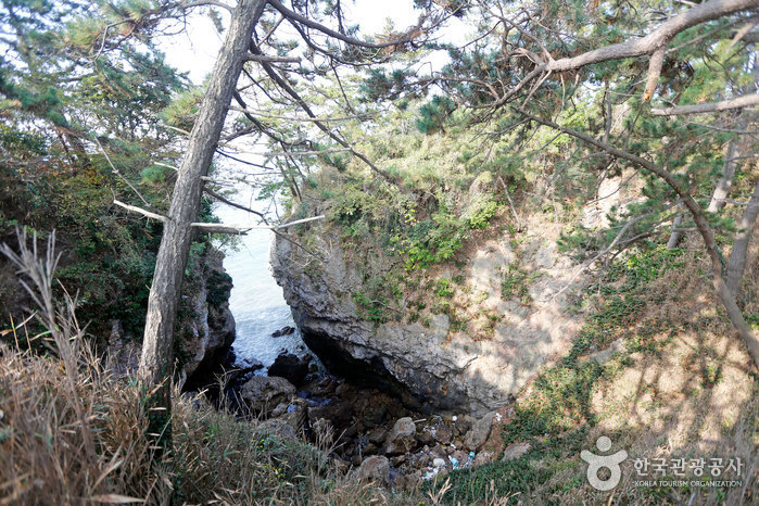
![Jeokbyeokgang Cliffs [National Geopark] (적벽강 (전북 서해안 국가지질공원))](http://tong.visitkorea.or.kr/cms/resource/30/3025630_image2_1.jpg)
Jeokbyeokgang Cliffs [National Geopark] (적벽강 (전북 서해안 국가지질공원))
14.5Km 2024-04-07
Gyeokpo-ri, Buan-gun, Jeonbuk-do
+82-63-584-0951
The area around Jeokbyeokgang Cliffs features great plant distribution value, including a population of Machilus, a designated natural monument. The cliffs are a great location for geological and ecological educational moments when visiting nearby attractions such as Chaeseokgang River and Gyeokgo Beach. The cliff is mostly composed of pepperlite, a unique rock that forms when volcanic rhyolite and sedimentary shale merge together.

Gunsan Sikdang (Buan) (군산식당(부안))
14.8Km 2024-04-07
16 Gyeokpohang-gil, Byeonsan-myeon, Buan-gun, Jeonbuk-do
Gunsan Sikdang is a renowned Korean restaurant famous for its clam porridge and clams set menu. Located near Gyeokpo Port and Chaeseokgang Cliff, this area is known for abundant clams. The signature menu is the baekhap jeongsik (clams set menu), featuring dishes such as clam porridge, steamed clams, clam soup, and various seafood dishes. Baekhap juk (clam porridge), boiled with mung beans, is also a specialty known for its rich flavor.
Suseongdang Shrine (수성당)
14.8Km 2025-01-15
54 Jeokbyeokgang-gil, Buan-gun, Jeonbuk-do
Located at the end of Jeokbyeokgang Cliff, Suseongdang Shrine is the only shrine in Korea that is dedicated to the sea god “Gaeyang Halmeoni” (Granny Gaeyang), the deity who rules over the West Sea, and her eight daughters. This is a place that holds rituals for the welfare and safety of fishers. Visitors can also see cairns dedicated to the fishermens’ safety. For tourists, however, this shrine is notable for its canola flowers. In early spring, the road connecting Suseongdang Shrine with Jeokbyeokgang Cliff blooms in yellow canola flowers, creating a beloved view and a premier photo area of the region. It is a recommended spot to see the flowers when visiting Buan in springtime.
 English
 한국어
한국어 日本語
日本語 中文(简体)
 Deutsch
 Français
 Español
 Русский