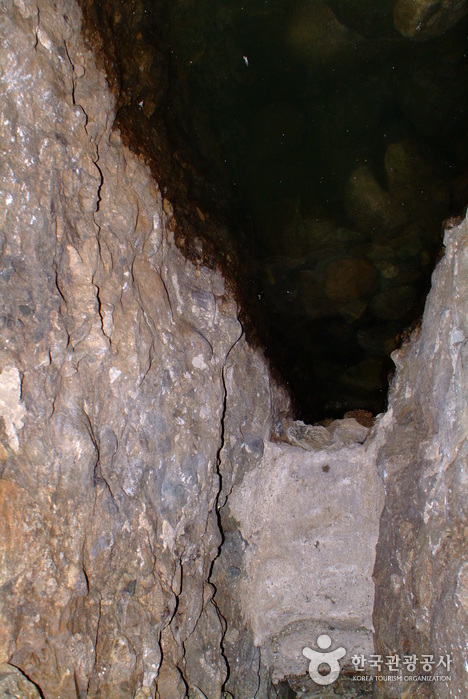
Maisan Hwaeomgul Cave (마이산 화엄굴)
13397 2024-04-07
367, Maisannam-ro, Jinan-gun, Jeonbuk-do
+82-63-430-8751
Maisan Mountain has two major peaks made of sedimentary rocks; these peaks are said to be ‘couple peaks’ and cannot be found anywhere else. Sut Maibong (alt. 667 meters) is said to be the male peak while the slightly larger Am Maibong (alt. 673 meters) is deemed the female peak. In the early Joseon period the mountain was named ‘Sokgeumsan,’ but began to be called ‘Maisan’ after the 12th year of King Taejong, who commented that the two peaks resembled horse ears (‘maisan’ meaning ‘horse ears’). All along Maisan Mountain, visitors will find small crater-like rock cavities that are formed by prolonged weathering. These unique geological features, called ‘tafoni,’ are of great academic value.
Inside Hwaeomgul Cave, visitors can observe medicinal water that flows up from underground all throughout the year. It is widely believed that once you drink the water, especially on the days of the Spring and Autumn Equinox, you will soon have a son and be blessed by the mountain spirit. Even today, many women who have difficulty conceiving visit the mountain to pray to the mountain spirits for their heart’s desire—the gift of a child. The region in which Maisan is located is the birthplace of many talented people and national heroes, which some say is proof of the blessings of the mountain and its extremely powerful spirit.

Iksan Sungnimsa Temple (숭림사(익산))
7496 2024-04-07
495-57, Baekje-ro, Iksan-si, Jeonbuk-do
+82-53-862-6394
Sungnimsa Temple is one of the major temples in Iksan under Geumsansa Temple and was believed by some to have been built by monk Jinpyo Yulsa during the reign of King Gyeongdeok (742-764) during the Silla period. Others believe that the temple was established during the first year of King Chungmok of the Goryeo dynasty in 1345. Sungnimsa Temple was named in honor of great monk Bodhi-Dharma, who practiced seated Zen meditation for nine years at Sorimsa Temple located deep inside Sungsan Mountain in China. The temple was burnt down during the Imjin War (1592-1598), leaving only Bogwangjeon Hall. Bits and pieces of the temple were later restored in 1697, 1819, and 1892.
Buan Guam-ri Dolmens (부안 구암리 지석묘군)
7213 2024-04-07
Seoksang-ri, Buan-gun, Jeonbuk-do
+82-63-580-4711
Buan Guam-ri Dolmens, designated as Historical Site No. 103, is comprised of southern-style dolmens. Dolmen refers to a particular structure of a tomb created during the Bronze Age. Dolmen is largely classified into two groups – Southern-type that has small footstones supporting large top stone; and Northern-type which is shaped like a desk. In Guam-ri, there were originally 13 dolmens, but only 10 remain. Most of the dolmens have 8 small footstones propping up one large top stone, compared to the dolmens in other regions which normally have 4 footstones.
O Sung Hanok Village (오성한옥마을)
0 2024-04-07
Daeheung-ri, Wangju-gun, Jeonbuk-do
+82-63-290-2727
Nestled between Jongnamsan Mountain and Wibongsan Mountain, O Sung Hanok Village has hanok mansion and approximately 20 hanok buildings consisting of cafes, galleries and more. The village also has various experience programs including forest walking trail that provides tradtional and cultural insights. The attraction is also known to visitors for its peaceful setting, bringing in visitors wanting to relax and meditate. Many artists who resides in the village offers gallery views, cafe, bookstore and more. In 2019, BTS stayed in the village for one week to shoot "BTS 2019 SUMMER PACKAGE" music videos and magazine photos. The village consistantly attracts ARMY and regular visitors.
Bandi Land (무주 반디랜드)
25024 2024-04-07
1324, Museol-ro, Muju-gun, Jeonbuk-do
+82-63-324-1155
Geared mainly towards children, Bandi Land is an excellent place to learn about and experience fireflies and other insects. It is comprised of Insect Museum, Firefly Research Center, Youth Campground, Log Cabin, and Firefly Habitat.
Located inside of Bandi Land, Muju Bandibyeol Astronomical Science Museum teaches various stories about space, including the birth & history of space, the solar system, constellations, and space circumstances. The Environment Theme Park also has exhibitions related to fireflies, an indicator insect proving Muju is a clean area, and other local insects, perfect for educational trips.
Banghwadong Recreational Forest (방화동 자연휴양림,가족휴가촌)
6039 2024-04-07
778, Banghwadong-ro, Jangsu-gun, Jeonbuk-do
+82-63-350-2474
Banghwadong Recreational Forest is located at the foot of Jangansan Mountain. The mountain trail from Deoksanyongso Pond leading to Banghwadonggyegok Valley features nature learning centers and adventure games facilities. The clean valley is lined with oddly shaped cliffs, shrubs and trees, which all combine into a splendid view. The forest is situated at a highland more than 500 meters above sea level. It is surrounded by mountains that are over a thousand meters above sea level, so the temperature is low and the water at the valley is cool even in the summer.
There are log cabins, group accommodation facilities, and training halls by the valley to accommodate group visits, conferences, gatherings and seminars. The recreational forest also operates Banghwadong Family Vacation Village for family visitors, equipped with accommodation facilities, various camping sites, and a wood carving experience center.
Nongae Shrine (Uiamsa Shrine) (논개사당(의암사))
13024 2024-04-07
393, Hannuri-ro, Jangsu-gun, Jeonbuk-do
+82-63-350-2326
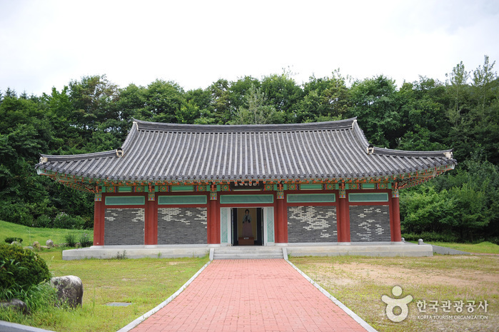
Uiamsa Shrine was built to the memory of Chu Nongae, who sacrificed her life during the Imjin War (Japanese Invasion of Korea). In 1846, the Nongae-saeng-jang-hyang-su-myeong-bi monument was put up in praise of Nongae’s patriotism. In 1955, a shrine was built and named Uiamsa, which was then moved to the current location in 1974. Within the precincts of the shrine are a memorial stone, the portrait of Nongae by artist Kim Eun-ho, and three gates Woesammun, Naesammun and Chunguimun erected one after another. At the memorial hall, the existing possessions of Nongae and her husband General Choi Gyeong-hoe are on display. The annual Nongae Festival takes places on September 3rd by the lunar calendar, during which memorial services and cultural events are held to commemorate Nongae.
Wansanchilbong Peak (Wansan Park) (완산칠봉(완산공원))
28424 2024-04-07
19-4, Gongsunae 1-gil, Wansan-gu, Jeonju-si, Jeonbuk-do
+82-63-220-5438
Wansanchilbong Peak, also referred to as Wansan Park, is located on the southern outskirts of downtown Jeonju. The mountain is known to be the origin of Iksan and Gunsan's birthplace and the mountain's fame had spread across the southern region along with Jeonju. In addition to the historically significant Chilseongsa Temple, there is a pavilion located at the top where people can look out over the surrounding area. The mountain is also a place where a fierce battle took place from the Donghak Peasant Revolution. Today, the mountain is made into a park and serves as a popular retreat for locals.
Birthplace of Nongae (논개생가)
15425 2024-04-07
558, Uiam-ro, Jangsu-gun, Jeonbuk-do
+82-63-350-1636
Nongae was born in Juchon Village in the 7th year of King Seonjo (September 3, 1575). A clever and beautiful young lady, Nongae voluntarily registered as a gisaeng (female entertainer) at the age of 19 when the nation was at risk of invasion during the Imjin War. While entertaining one evening, she led Japanese general Keyamura Rokusuke to the edge of a cliff and flung her arms around him, casting both herself and the general to their deaths in the Jinju Namgang River.
To commemorate her faithfulness and allegiance to her country, a project to restore her place of birth was completed in September 2000, drawing many visitors. Nearby Nongae’s birthplace are many tourist attractions, including Deogyusan Mountain and Odongje Pass and a hiking trail that connects Jangansan County Park, Jijigyegok Valley, and Donghwa Dam.
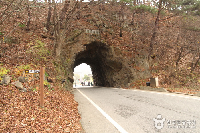
Rajetongmun Gate (라제통문)
25126 2024-04-07
Rajetongmun-ro, Muju-gun, Jeonbuk-do
+82-63-322-2905
The historical border of the Silla and Baekje Kingdoms, Rajetongmun Gate of Seolcheon-myeon, Muju was formed from a rock cave in Seokgyeonsan Mountain. The tunnel is approximately 3 meters in x_height and 10 meters in length, and divides the villages of Sindu Maeul into Dugil-ri, Seolcheon-myeon and Inam Maeul in Socheon-ri. During the Three Kingdoms Period, the rocky ridges of Seokgyeonsan Mountain drew the boundary of Silla's Mupung in the east with Baekje's Seolcheo to the west.
Tracing the history from the Three Kingdoms Period to the Goryeo dynasty, the cultures and traditions of the two regions were markedly different. If curious about the difference, one could simply stop by Seolcheon on market day, where the Muju and Mupung local
dialects and customs can easily be distinguished.
People used to cross Seokgyeonsan Mountain by a footpath along the rocky ridge to travel between Seolcheon and Mupung. During the Japanese occupation, a new road was created by turning a cave into a tunnel through the mountain so cows and horse carts could freely pass from Muju to Gimcheon.
General Kim Yoo Shin from the Silla Kingdom, the hero of unification of the Three Kingdoms, often passed by the gate, later giving rise to the gate's nickname, Tongilmun (literally "Unification Gate"). The gate
is number one on the list of 33 scenic sites in Gucheon-dong.
 English
 한국어
한국어 日本語
日本語 中文(简体)
 Deutsch
 Français
 Español
 Русский