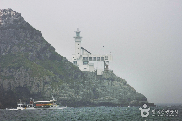
Oryukdo Lighthouse (오륙도 등대)
0m 29098 2020-02-26
130, Oryukdo-ro, Nam-gu, Busan
+82-51-607-6395
Oryukdo is a rocky island located in the oceanside of the Yongho-dong neighborhood. Depending on the tides, Oryukdo (“O” meaning “5”, “Yuk” meaning “6”) sometimes looks as if it is made of five or six islets. Several decades after the Busanhang Port opened (1876), a lighthouse was built (November 1937) in Batseom Island of Oryukdo to guide ships traveling to and from the island. Initially only 6.2 meters high, the lighthouse underwent renovations (completed in December 1998) and now stands tall at 27.5 meters. The lighthouse is home to an exhibition room showing photos of major lighthouses in Korea and boasts a stunning view of Busanhang Port as well as an unforgettable nightscape.
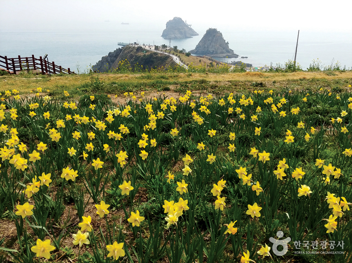
Oryukdo Islets (Busan National Geopark) (오륙도 (부산 국가지질공원))
1.2 Km 79516 2024-03-05
137 Oryukdo-ro, Nam-gu, Busan
+82-51-888-3636
Oryukdo Islets consists of six rocky islets located in the sea at the southern end of Igidae Park, appearing as either five or six depending on the tide. The islets, closest to the mainland, are named Bangpaeseom Island, Solseom Island, Suriseom Island, Songgotseom Island, Gulseom Island, and Deungdaeseom Island, with only the Deungdaeseom Island accessible to visitors. From the Oryukdo Skywalk at Oryukdo Sunrise Park, visitors can enjoy even better views of the islets.

Haeparang Trail Course 1 (해파랑길 1코스)
1.2 Km 0 2023-02-03
137, Oryukdo-ro, Nam-gu, Busan
+82-51-607-6395
The first course of Haeparang Trail is a coastal road connecting Yongho-dong, Nam-gu and Jung 2-dong, Haeundae-gu in Busan, starting from Oryukdo Sunrise Park, passing Gwangallihaebyeon Beach and APEC Beach, to Mipo. Not only can visitors enjoy the sea cliffs and the natural scenery of the East Coast, but also the splendid and bustling Gwangalli and Haeundae tours.
Oryukdo Skywalk (오륙도 스카이워크)
1.3 Km 152819 2023-01-09
137, Oryukdo-ro, Nam-gu, Busan
+82-51-607-6395
Oryukdo Skywalk is located at what was called Seungdumal, meaning a saddle, due to the shape of the point. It was also called Jallokgae by residents and female divers in the area.
The construction of Oryukdo Skywalk began on September 12, 2012, at the Seungdumal area, which is regarded as the dividing point between the East Sea and the South Sea, and the skywalk opened on October 18, 2013, with the theme of "walking over the sky.”
Iron columns were set up over a 35-meter-high coastal cliff, and a 15-meter glass bridge comprised of 24 glass plates and shaped like a horse’s hoof connect the iron columns. The glass flooring was made by four layers of 12-millimeter glass panels coated with a bulletproof film for a total thickness of 55.49 millimeters, making the structure quite safe. Visitors will be thrilled with the view of the waves while looking down through the transparent floor. The sea stretches out ahead of the skywalk, perfect for a photo op.
Sinseondae Cliff (신선대 (부산))
2.5 Km 9092 2019-01-16
6, Sinseon-ro 303beon-gil, Nam-gu, Busan
+82-51-253-8253
Stretched out from Hwangryeongsan Mountain, Sinseondae Cliff is namely the most popular viewing spotl ocated in Busan's coastal area. Thanks to its geological location, the Sinseondae commends imcomparable ocean vista over many other small islets scattered around the bay area. The site is 4,121.707 ㎥, fairly flat and even therefore a perfect place for visitors to stroll around the area. An old folktale has it that, the name 'sinseon' (or Taoist in English) was given because the sacred people came to the mountain to rest and play, attracted by its spectacular view. The area has been highly appreciated by visitors for some hundreds of decades, and a documentary from one notable scholar from the Silla Era, Choi Chi-won, testifies the impressive looks from during his time.
Igidae Cliff (Busan National Geopark) (이기대 (부산 국가지질공원))
2.8 Km 41252 2024-03-05
Yongho-dong, Nam-gu, Busan
+82-51-888-3636
Igidae Cliff is a geological park located along the southern coast of Busan. Formed by volcanic activity dating back 80 million years to the Cretaceous period, the accumulated lava, volcanic ash, and other rocks have been eroded by waves, creating cliffs, caves, and other formations. Along the coastal trail leading to Oryukdo, visitors can appreciate various geological and topographical landscapes, including copper mines and pothole.
![Olive Young - Busan Yongho Branch [Tax Refund Shop] (올리브영 부산용호)](http://tong.visitkorea.or.kr/cms/resource/56/2885756_image2_1.jpg)
Olive Young - Busan Yongho Branch [Tax Refund Shop] (올리브영 부산용호)
3.4 Km 0 2024-04-18
139, Dongmyeong-ro, Nam-gu, Busan
-
Marine Adventure Park (마린어드벤처파크)
3.6 Km 0 2024-03-29
727 Taejong-ro, Yeongdo-gu, Busan
Marine Adventure Park is a park where visitors can enjoy thrilling marine sports on the blue sea of Busan. The jet boat, which sails the sea with 440 horsepower, is famous for its exhilarating speed and 360-degree turns. Moreover, round boats driven by jet skis and marble boats for four people constantly turn and shake the passengers off balance. Visitors can also enjoy SUP yoga on a stand-up paddle board on the sea. Packages consisting of two or three activities are cheaper than regular prices.

Halmae Patbingsu Danpatjuk (할매팥빙수단팥죽)
3.9 Km 15841 2019-11-11
24, Yongho-ro 90beon-gil, Nam-gu, Busan
+82-51-623-9946
Halmae Patbingsu Danpatjuk has over 30 years' experience in pat bingsu (shaved ice with sweetened red beans) and danpatjuk (sweet red bean porridge). Located in Yongho-dong, the restaurant is close to Igidae Park, and therefore easily accessible by bus through the Igidae Park bus stop.
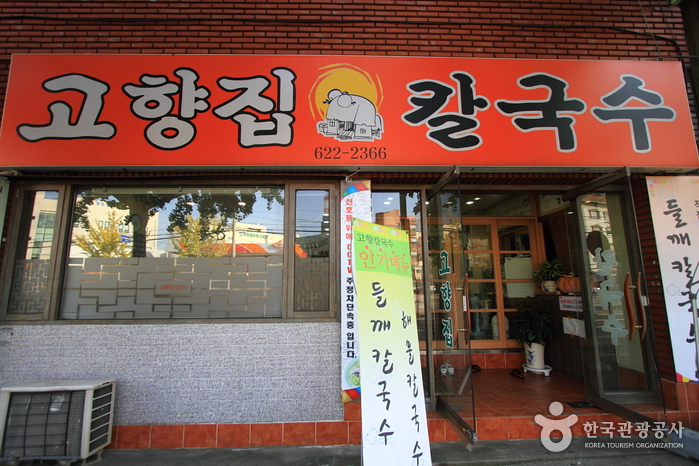
Gohyangjip Kalguksu (고향집칼국수)
4.2 Km 16957 2019-08-17
397-2, Sinseon-ro, Nam-gu, Busan
+82-51-622-2366
Gohyangjip Kalguksu offers kal-guksu (noodle soup) using red pepper powder, rice, and seasonal vegetables.
 English
 한국어
한국어 日本語
日本語 中文(简体)
 Deutsch
 Français
 Español
 Русский